

Earth undergoes continuous transformation through various factors, from natural phenomena such as volcanic activity and crustal deformation to human activities, including large-scale civil engineering projects and mining development. Rapidly and accurately capturing these topographical changes, particularly large-scale transformations across extensive areas, is critically important for safety management, environmental conservation, and efficient economic activities.
To address this challenge, Synspective has developed InSAR dDEM (patents pending: PCT/JP2024/009808, PCT/JP2024/034171), which quantitatively measures meter-scale topographical changes with high frequency and resolution. This technology provides new insights into Earth’s surface processes, enabling, detection of previously unobservable changes.
1. InSAR Conventional Wisdom and “Unexpected Limitations”
InSAR analysis captures ground movement using satellite data. Understanding this technology requires knowledge of two primary methodologies.
The first is Differential Interferometric SAR (DInSAR), which compares two SAR images captured at different times to detect centimeter-level surface displacement. This method is well-suited for capturing rapid changes over short periods, such as crustal movements caused by earthquakes.
The second method is Time-Series InSAR, which represents a further revolution of DInSAR. Analyzing ten or more SAR images in temporal sequence reduces noise from atmospheric effects, enabling continuous monitoring of ground movement with millimeter-level precision. This method demonstrates significant capability for monitoring long-term phenomena, such as ground subsidence in urban areas or minute infrastructure deformation.
However, these high-precision conventional technologies had an unexpected limitation: difficulty in capturing large changes. Why would precise technology capable of detecting millimeter-level movements overlook large meter-scale changes? This stems from the fact that InSAR measures wave displacement (phase differences). When changes are too large, it becomes impossible to determine how many cycles the wave has shifted, preventing accurate displacement calculations. This is analogous to attempting to measure an object several meters long using only a short 10 cm ruler with millimeter markings, where you lose track of your starting measurement point.
Consequently, in cases where the surface undergoes large meter-scale changes, such as major landslides after a disaster or dramatic topographical changes at mining sites, this phase decorrelation becomes a bottleneck, making accurate analysis difficult. Conversely, while aerial laser surveying and drone-based surveys offer high precision, they require significant cost and time to cover extensive areas and are limited by weather conditions. Therefore, existing technologies could not fully meet the pressing need in disaster prevention and large-scale development contexts: high-frequency, wide-area monitoring of meter-scale topographical changes.
2. New InSAR dDEM Technology Visualizes Meter-Scale Changes
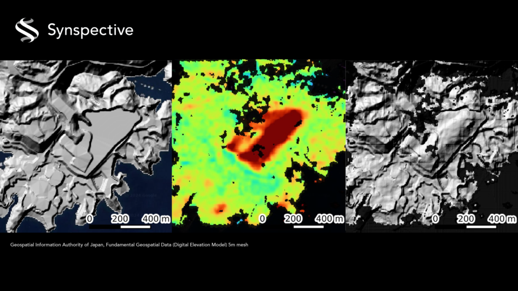
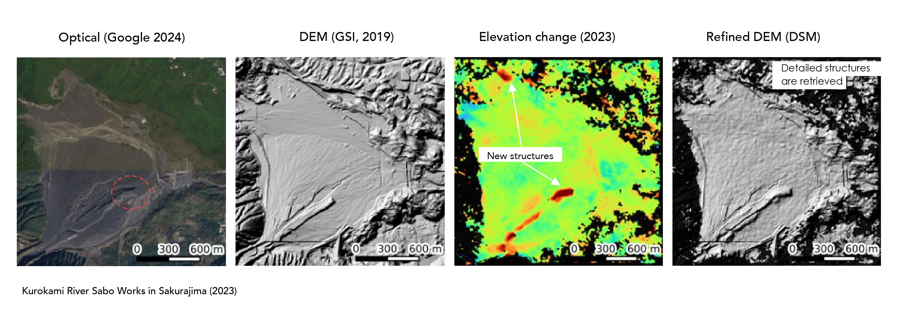
Synspective’s new InSAR dDEM technology was developed to address these needs and overcome traditional technical limitations. While conventional InSAR measures ground displacement (movement), InSAR dDEM measures elevation changes (such as the embankment volumes or excavation) at meter-scale precision. The principle utilizes phase information differences from SAR images SAR images captured at two different positions to calculate elevation, which shares common principles with existing global digital elevation models (DEMs), such as SRTM and Copernicus DEM. InSAR dDEM applies this principle by comparing elevation data generated at different times to reveal topographical changes that occurred during the intervening period.
This technology enables applications across the following diverse fields:
- Rapid Disaster Management and Recovery Support: Immediately following large-scale landslides or debris flows caused by earthquakes or heavy rainfall, a detailed assessment of damage conditions in dangerous mountainous areas inaccessible to humans becomes possible within just a few days of the disaster occurrence. This data is expected to be utilized for emergency response, secondary disaster risk assessment, and recovery plan development.
- Monitoring Illegal Topographical Modifications and Environmental Protection: High-frequency, low-cost monitoring of topographical changes, such as illegal embankments, excavation, and unauthorized waste disposal, in mountainous areas where human oversight is difficult, becomes possible. By accurately detecting where, when, and at what scale changes occurred, this technology significantly reduces the burden of administrative monitoring operations.
- Safety and Progress Management at Mines and Civil Engineering Sites: Periodic monitoring of tailing storage facility stability at mining sites and topographical changes during large-scale excavation and embankment construction becomes possible. This significantly reduces costs and time compared to conventional survey methods, contributing to improved safety management and productivity.
- Efficient Water Resource and River Basin Management: Efficient assessment of wide-area sediment dynamics becomes possible, including understanding river deposition and erosion patterns and measuring sediment accumulation in erosion control dams, tasks that previously required extensive field investigation efforts.
- Volcanic Activity Monitoring: Active volcanoes, continuous capture of topographical changes such as new craters formed by eruptions, and modifications caused by lava flows become possible. This provides critically important data for understanding eruption conditions and protecting the safety of residents.
3. The Behind-the-Scenes Story of “InSAR dDEM” Made Possible by StriX
InSAR dDEM is a technology that can be applied to other SAR satellites when conditions are appropriate. However, the ability to maximize its potential and establish it as a practical solution stems from the unique characteristics specific to Synspective’s small SAR satellite StriX.
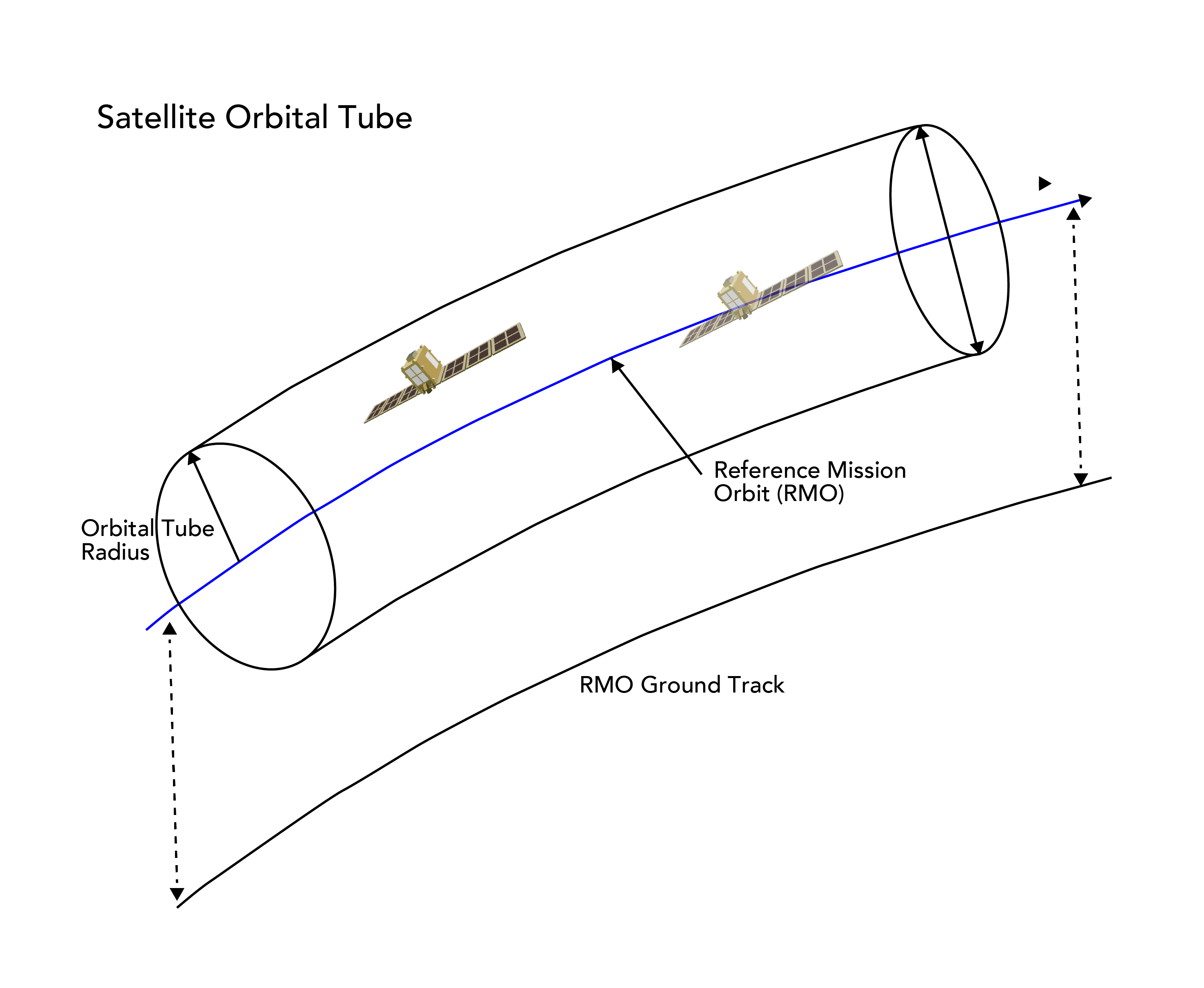
The key factor is the orbital separation when the satellite observes the same location twice, known as the perpendicular baseline (B⊥). In conventional InSAR for observing millimeter-level displacement, maintaining extremely close B⊥ values has been considered essential for high precision. Therefore, large SAR satellites, such as Sentinel-1 and ALOS-2, maintain strictly controlled orbits with consistently close B⊥ maintain a consistently short baseline.
However, InSAR dDEM, which captures large meter-scale elevation changes, requires the opposite: B⊥ values that are separated to some degree (approximately several hundred meters). These “just right” observation pairs with optimal spacing are rarely obtainable from large satellites with strictly controlled orbits, which lack sensitivity to elevation changes.
Because we are in the process of building out the StriX constellation, it naturally generates observation pairs with various B⊥ values, creating an ideal environment for obtaining data optimal for InSAR dDEM. Since our satellite orbital conditions can be predicted several weeks in advance, data acquisition at optimal timing becomes possible, which also contributes to technological improvement.
Additionally, StriX, which employs uX-band technology, can observe the same locations through combinations of sun-synchronous orbits and orbital inclinations, enabling a response to meet high-frequency demands such as rapid situational awareness immediately after disaster occurrence and monitoring of constantly changing mining sites. This technology emerged from the convergence of deep knowledge cultivated through years of InSAR research, business sector demands to see large changes, and confidence in our own assets that StriX, in its current state, can achieve this.
4. The “Strength” of an End-to-End System that Accelerates Innovation
Our company continues to create patented technologies related to SAR satellites and solutions. The driving force behind this is Synspective’s unique end-to-end system, which covers everything from satellite development and operation to data analysis and solution development.
For example, suppose an analyst formulates the hypothesis that, “if we could observe from this specific angle two hours earlier, we should be able to obtain more accurate data.” At Synspective, such ideas can be reflected in satellite observation plans within hours, with the resulting data delivered in the analyst’s hands the next day, achieving this level of responsiveness. Furthermore, the environment where analysts can immediately consult with professionals who understand satellite design and image processing enables rapid hypothesis-testing cycles, which serve as a driving force for innovation.
This environment accelerates the development of new analytical techniques by exploring combinations that no one has attempted before. InSAR dDEM exemplifies precisely this approach, leveraging StriX satellite characteristics (specific orbital control state due to its developmental stage) to solve challenges that were difficult for conventional large satellites.
In the future, as the number of satellites in the StriX constellation increases and orbital control technology evolves, data acquisition opportunities will further expand, with applications anticipated across various fields.