Our StriX satellites use Synthetic Aperture Radar (SAR) to observe and analyze the Earth’s surface down to sub-meter resolutions.
Satellite Orbit and Specifications
Our small SAR satellite StriX boasts a larger swath, lower noise and wider area than other satellites in its class. Our first Strix satellite was placed in orbit in 2020, with more satellites being added each year.
Operating at a nominal altitude of 500km or higher, StriX follows a sun-synchronous or inclined orbit typical of other Earth observation satellites and is capable of making daily visits to the same location. This visit frequency will only increase as our constellation grows in size.
Our StriX satellites emit a 9.65GHz (X-band) frequency microwave signal directed at a target on Earth. The amount of signal reflected (“backscatter”) gives a realistic image of the terrain and structural properties at the target location. This is known as a “synthetic aperture” because the moving satellite uses multiple signal captures to mimic the effect of placing one massive antenna in orbit.
Observation Modes
Our StriX satellites offer three observation modes: Stripmap, Sliding Spotlight and Staring Spotlight. The choice of mode reflects the priority placed on either area or resolution.
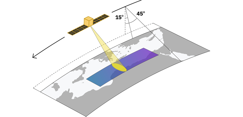
Stripmap Mode
In the Stripmap mode, the center of the antenna beam moves in conjunction with the satellite at an approximately fixed off-nadir angle. While inside the antenna beam, the ground is illuminated with a sequence of electromagnetic waves at radiofrequency . The outcome of this imaging mode is a long swath image with a nominal slant range resolution of 1.8 meters and a nominal slant-azimuth resolution of 2.6 meters. Stripmap is the optimal mode for large-area capture.
Specifications of Stripmap Mode
| Observation mode | Stripmap |
| Nominal swath width [km] | 10-30 (Nominal20) |
| Nominal product length [km] | 50-70 |
| NESZ [dB] | -21.7 * |
| Azimusth S/A [dB] | 13.2 * |
| Range S/A [dB] | 26.0 * |
| Slant range resolution [m] | 1.8 |
| Ground range resolution [m] | 3.6 |
| Azimuth resolution [m] | 2.6 |
* The values reported in this table refer to latest expected performance of StriX satellites
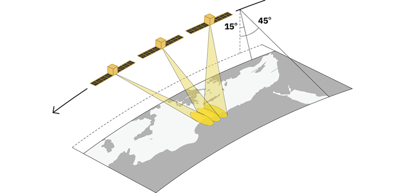
Sliding Spotlight Mode
In this mode, the antenna beam is steered during data acquisition to allow a longer observation of a selected area. Because the antenna beam moves at a slower rate, more data is collected. Sliding Spotlight modes are available; one has 0.9 m ground range and 0.9 m azimuth resolution (Sliding Spotlight 1), whereas the other has 0.46 m ground range resolution and 0.5 m azimuth resolution (Sliding Spotlight 2).
Specifications of Sliding Spotlight Mode
| Modes | Sliding Spotlight 1 | Sliding Spotlight 2 |
| Nominal swath width [km] | 10 *1 | |
| Nominal product length [km] | 10 | |
| NESZ [dB] | -15.7 *2,*3 | -15.4 *2,*3 |
| Azimuth S/A (ASAR) [dB] | 20.2 *2,*3 | 28.9 *2,*3 |
| Range S/A (RSAR) [dB] | 23.5 *2,*3 | 16.5 *2,*3 |
| Slant range resolution [m] | 0.5 | 0.23 |
| Ground range resolution [m] | 0.9 *2 | 0.46 *2 |
| Azimuth resolution [m] | 0.9 | 0.5 |
*2. Analysis value at an off nadir angle of 30 degree
*3. The values reported in this table refer to the lowest expected performance of StriX satellites
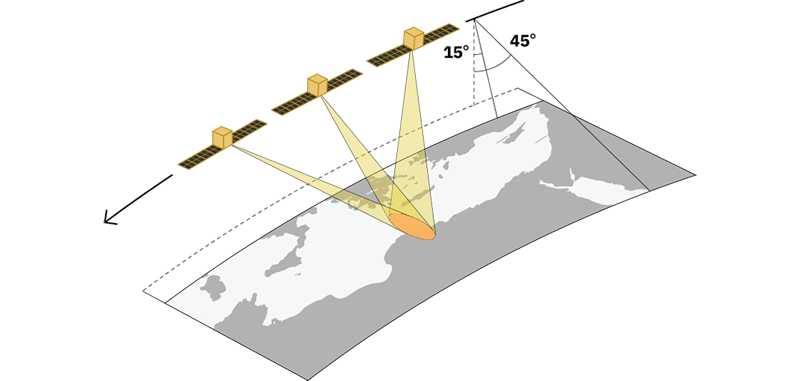
Staring Spotlight Mode
Similar to Sliding Spotlight mode, in Staring Spotlight mode, the antenna beam is steered mechanically throughout the data acquisition. However, in Staring Spotlight mode, the rotation center is on the Earth’s surface, allowing the scene’s area to be concentrated on a smaller area. As a result, Staring Spotlight mode provides a finer azimuth resolution. Five different Staring Spotlight modes are available, consisting of combinations of the chirp bandwidth and observation duration. “Staring Spotlight 4” has the finest range and azimuth resolution. The newly added “Spotlight Enhanced” is multilooked with 3 looks in the azimuth direction to reduce speckle noise, and its resolution is made equivalent to Staring Spotlight 3.
Specifications of Staring Spotlight Mode
| Observation mode | Staring Spotlight 1 | Staring Spotlight 2 |
| Nominal swath width [km] | 10 *1 | |
| Nominal product length [km] | 3 | |
| NESZ[dB] | -17.4 *2,*3 | |
| Azimusth S/A [dB] | 20.2 *2,*3 | |
| Range S/A [dB] | 23.5 *2,*3 | |
| Slant range resolution [m] | 0.5 | |
| Ground range resolution [m] | 0.9 *2 | |
| Azimuth resolution [m] | 0.5 | 0.25 |
| Observation mode | Staring Spotlight 3 | Staring Spotlight 4 |
| Nominal swath width [km] | 10 *1 | |
| Nominal product length [km] | 3 | |
| NESZ[dB] | -17.1 *2,*3 | |
| Azimusth S/A [dB] | 30.4 *2,*3 | |
| Range S/A [dB] | 16.5 *2,*3 | |
| Slant range resolution [m] | 0.23 | |
| Ground range resolution [m] | 0.46 *2 | |
| Azimuth resolution [m] | 0.5 | 0.25 |
| Observation mode | Spotlight Enhanced |
| Nominal swath width [km] | 10 *1 |
| Nominal product length [km] | 3 |
| NESZ[dB] | -17.1 *2,*3 |
| Azimusth S/A [dB] | 30.4 *2,*3 |
| Range S/A [dB] | 16.5 *2,*3 |
| Slant range resolution [m] | NA *4 |
| Ground range resolution [m] | 0.46 *2 |
| Azimuth resolution [m] | 0.5 *5 |
*1 This may vary depending on the observation condition such as offnadir
*2 This is an analysis value at an offnadir angle of 30 degree
*3 The values reported in this table refer to the lowest expected performance of StriX satellites
*4 For Spotlight Enhanced, only Ground Range Detectes (GRD) products are available. Thus, the slant range resolution is noted as Not Applicable (NA).
*5 This resolution is after multilooked by 3 looks
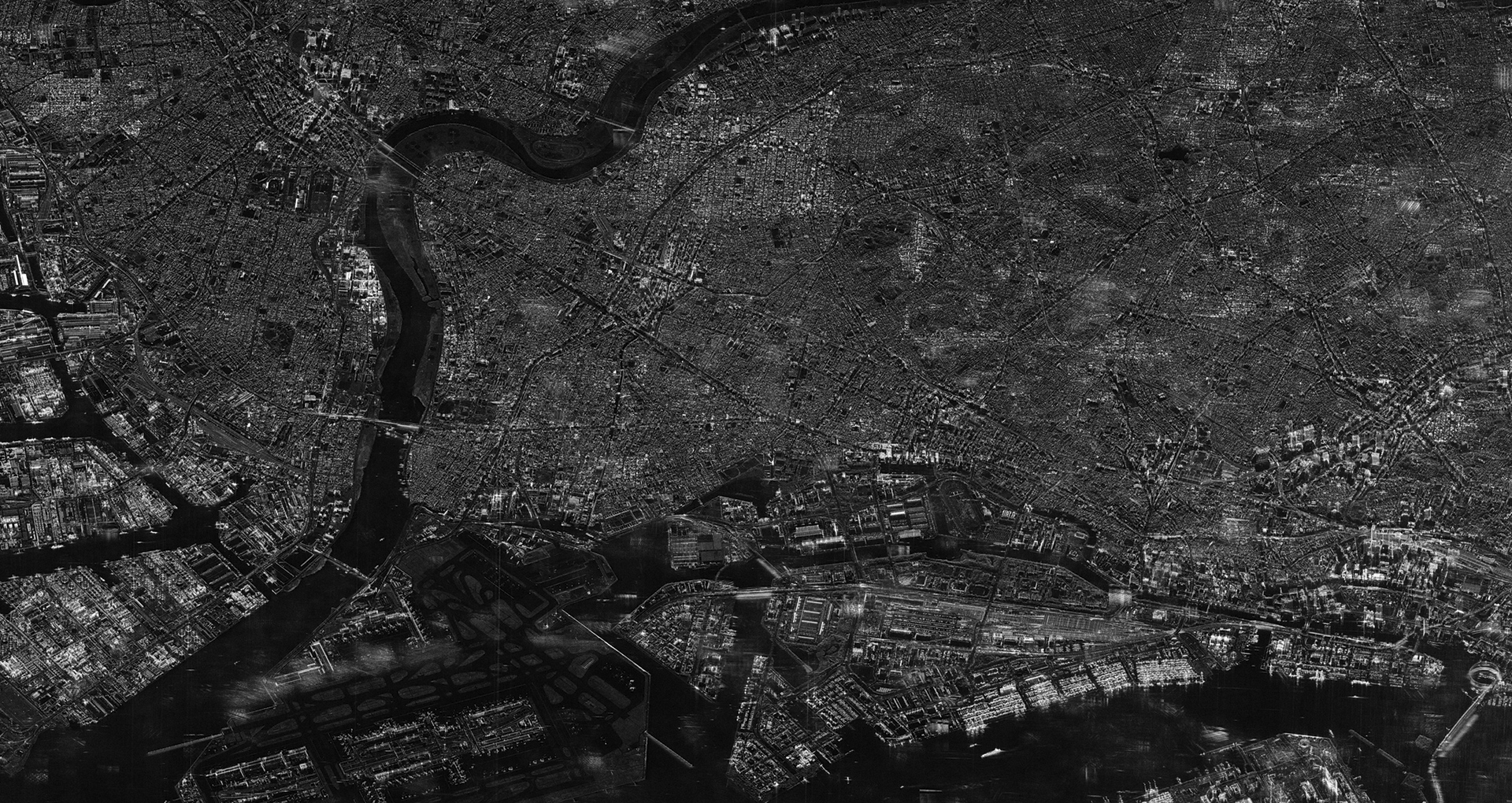
Observation Example in Spotlight Enhanced Mode
The Spotlight Enhanced mode applies a 3-look multilook processing in the azimuth direction to effectively suppress the speckle noise characteristic of SAR imagery.
In this image of Narita Airport acquired in March 2026, complex infrastructure such as runways and terminal buildings can be seen with high clarity, and the boundaries between the airport and surrounding terrain or vegetation are clearly defined. Offering high resolution with reduced noise, this mode is highly effective not only for technical analysis but also for general situational awareness, infrastructure monitoring, and public relations purposes where an easy-to-understand visual is key.
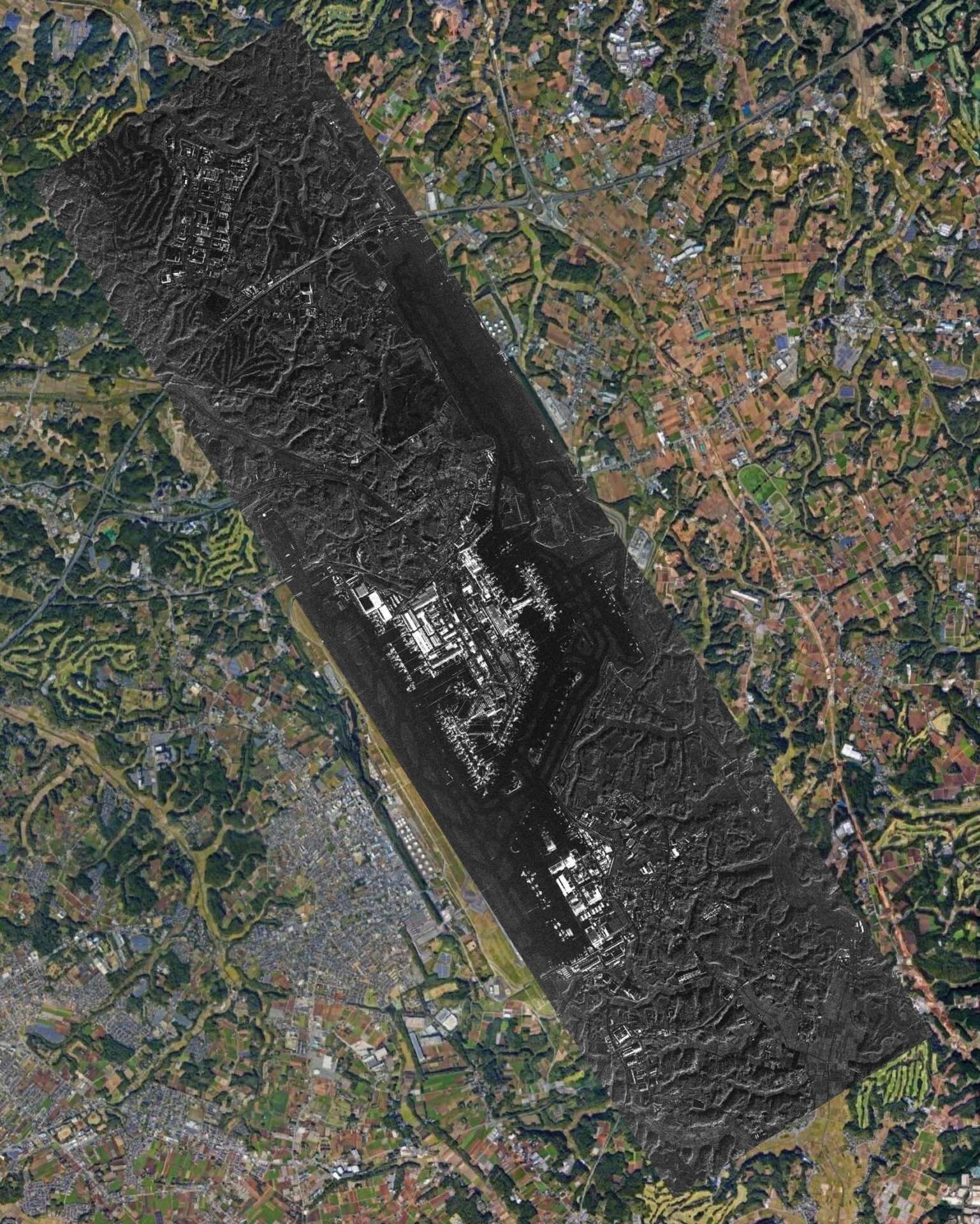
Map data © 2026 Google, Airbus
Acquisition Date: March 28, 2026, 06:38 UTC
Satellite: StriX
Mode: Spotlight Enhanced (Left-looking / Ascending)
Off-nadir Angle: Approx. 37.7°
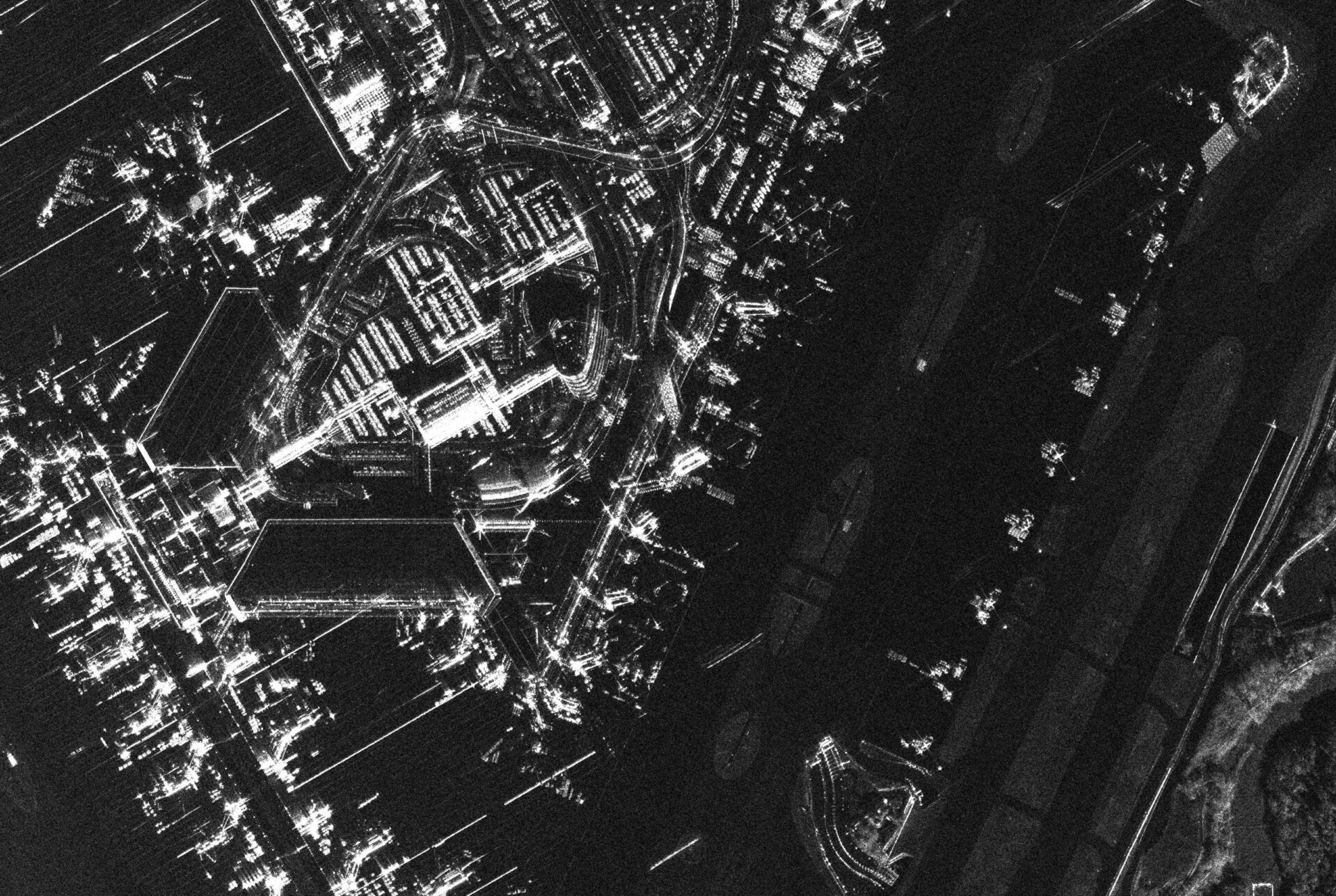
Image 1-A (Top): Spotlight Enhanced Image (50cm, 3-look)
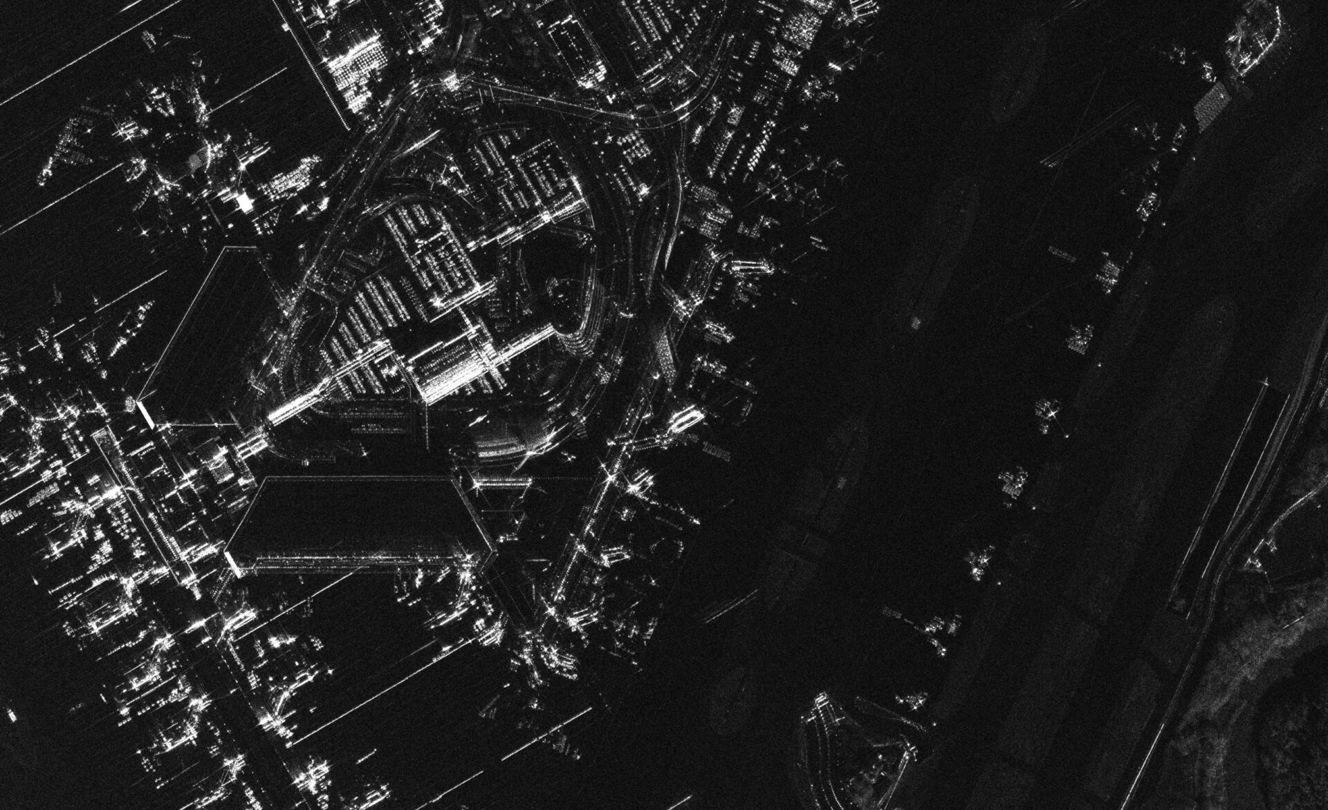
Image 1-B (Bottom): 25cm High-Resolution Image (Single-look)
Close-up DetailClose-up 1: Airport Terminal Area (Comparison of Spotlight Enhanced and High-Resolution Single-Look)s Highlight Visual Clarity
Comparing the Spotlight Enhanced image (50cm, 3-look in the azimuth direction) with the 25cm single-look high-resolution image reveals that the Spotlight Enhanced mode smooths out the noise, depicting the surfaces and shapes of structures with greater continuity. While the single-look image has a higher spatial resolution (better at capturing fine point targets), it retains prominent, granular speckle noise. In contrast, the Spotlight Enhanced mode effectively suppresses this graininess on surfaces such as roofs and paved areas. As a result, the complex shapes of the terminal buildings and surrounding road networks appear more cohesive and closer to their actual physical structures.
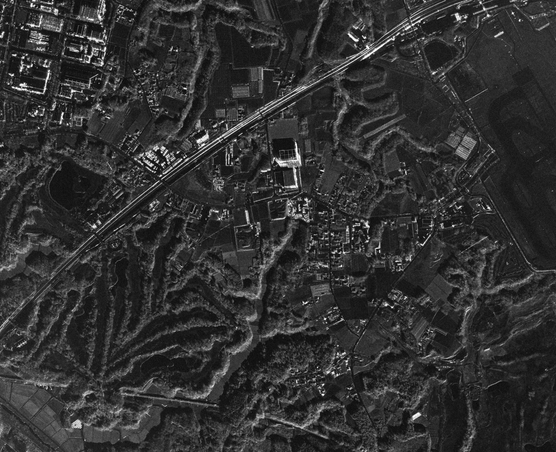
Close-up 2: Adjacent Golf Course and Natural Terrain
Beyond infrastructure, the boundaries of natural features such as forests, agricultural fields, and the layouts of the golf course (fairways and bunkers) are clearly defined. This noise reduction allows users to intuitively grasp the differences in surface textures across diverse terrains.
Product Processing Levels and Data Formats
StriX SAR data products are defined by a combination of the “processing level,” which indicates how the image is processed, and the “data format” (file format) in which it is delivered. There are four processing levels:
- SLC: Complex data containing both amplitude and phase. Used for interferometry (InSAR) and change detection.
- GRD: A real-valued image projected onto the ground using an Earth ellipsoid model. It contains no phase information and is oriented the same way as a map.
- Super-Resolution GRD (SR-GRD): A GRD sharpened by suppressing sidelobes.
- ORTA product with high positional accuracy, corrected for terrain-induced distortion using a DEM.
Note: “GRD” is a processing level, whereas “CEOS” and “SICD” (described below) are data formats — they belong to different categories.
ORT (Orthorectified) Product
ORT is a terrain-corrected product generated from SLC data using a digital elevation model (DEM / Copernicus DEM GLO-30). Unlike GRD and Super-Resolution GRD, which are projected onto an ellipsoid, ORT corrects terrain-induced distortions such as foreshortening and layover, achieving high positional accuracy even in areas with significant relief.
Because it is projected onto a fixed UTM grid, time-series analysis is possible without resampling. Two types of backscatter data are provided depending on the use case:
- ORT sigma-naught: The same backscatter definition as GRD (the effect of terrain slope remains).
- ORT gamma-naught: Radiometric terrain correction (RTC) removes the effect of slope. Suited for quantitative backscatter analysis and time-series monitoring.
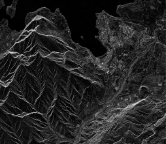
a) GRD sigma-naught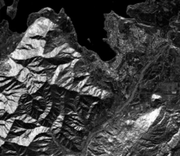
b) ORT sigma-naught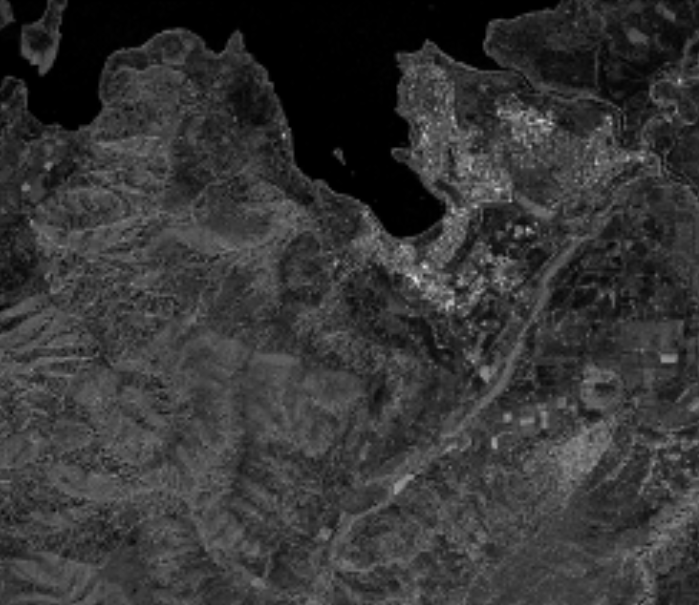
c) ORT gamma-naught
Comparison of GRD, ORT sigma-naught, and ORT gamma-naught over a mountainous scene. Viewing direction is from the north (top to bottom).
Produced using Copernicus WorldDEM™-30 © DLR e.V. 2010–2014 and © Airbus Defence and Space GmbH 2014–2018 provided under COPERNICUS by the European Union and ESA; all rights reserved.
Data Format
Image data is provided in CEOS or SICD format for SLC products, and in GeoTIFF + XML format (COG) for GRD, Super-Resolution GRD, and ORT products. CEOS is a format suited for storing complex images and their processing parameters, while SICD is the standard SLC format defined by the U.S. National Geospatial-Intelligence Agency (NGA).
| Observation Mode | SLC | GRD / SR-GRD | ORT |
| Stripmap | CEOS or SICD | GeoTIFF+XML | GeoTIFF+XML |
| Sliding Spotlight | CEOS or SICD | GeoTIFF+XML | GeoTIFF+XML |
| Staring Spotlight | CEOS or SICD | GeoTIFF+XML | GeoTIFF+XML |
| Spotlight Enhanced | Not available | GeoTIFF+XML (GRD only) | Not available |
Learn More
Looking to acquire SAR data for your organization? Download a complete product guide from the page below.