The Future Enabled by a SAR Satellite Constellation
We are planning to establish a production facility in 2024 and aim to build a constellation of 30 satellites by the latter half of this decade.
It will also make it possible to quickly monitor and confirm on-the-ground changes during disasters such as earthquakes and floods at night, as well as in areas that are difficult to access.
In addition to disaster response, we will leverage our SAR satellite capabilities to promote efficient resource utilization. For example, we can use our satellite data to monitor natural resources and urban development, ensuring sustainable and optimal use of land and water. Furthermore, we will play a crucial role in developing and maintaining infrastructure that is both safe and resistant to disasters. This includes using our SAR data for early detection of structural weaknesses or potential failures. In the realm of security, our enhanced SAR imaging and analysis will not only improve information gathering but also strengthen response strategies.

The Vision for the Constellation and the Orbit’s Importance
Artificial satellites are categorized into three main types: communication, positioning, and Earth observation satellites. Additionally, Earth observation satellites are divided into optical and Synthetic Aperture Radar (SAR) types.
Among these, we are involved in the development, manufacturing, and operation of SAR satellites. Our satellites, which are classified as Earth observation satellites, observe terrain and the shape of structures.
In building a constellation, factors such as the number of satellites, their resolution, and latency (including order processing times) are crucial.
Equally important is the choice of orbit for deploying satellites, especially when providing datasets for time series analysis and change detection, which are distinctive capabilities of SAR satellites.
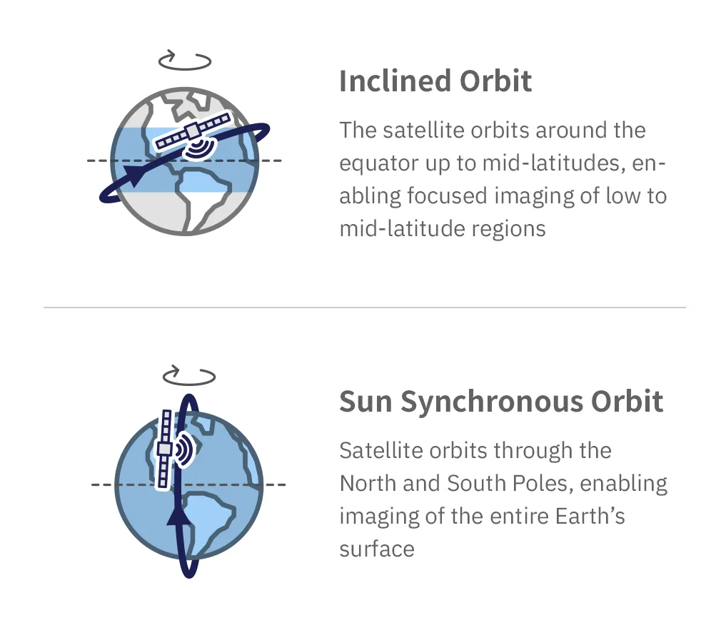
Traditional large SAR satellites are designed with a focus on maximizing coverage with each individual satellite, using a sun-synchronous orbit to ensure global reach.This orbit enables them to pass over the same area at consistent local solar times, typically every few days.
On the other hand, with smaller SAR satellites, it is feasible to develop and launch multiple satellites for the equivalent cost of one large satellite. By deploying these smaller satellites into sun-synchronous orbits, global coverage can be achieved more effectively.
Utilizing Varied Sun-Synchronous Orbits
The orbital inclination is important in determining the satellite’s coverage area. The orbital inclination angle indicates the angle between the satellite’s orbit and the Earth’s equatorial plane.
By choosing a sun-synchronous orbit, which by design is inclined, it’s possible to focus on densely populated areas in low to mid-latitude regions. This enables the effective capture of images in high-demand areas.
Due to some constraints, there are areas that become invisible, caused by the relationship between the satellite’s imaging direction/angle and the land’s slope gradient. By utilizing sun-synchronous orbits, it is possible to capture images from all four cardinal directions (east, west, south, and north), enabling the selection of imaging combinations that effectively avoid these invisible areas. We are planning on building a constellation that combines multiple orbits.
SAR Data for Capturing Change and Guiding Future Actions
Users solving problems with SAR data have varying needs depending on their objectives and applications. Some may request imaging at specific times and locations. Others might wish to observe changes at the same time and place on a daily basis.
Also, providing real-time data during disasters is important, but there are also cases where observing changes caused by disasters is desired. For example, if we compare data from a year ago, it’s unclear whether the changes observed are due to the disaster or other changes that happened over the year.
We believe that being able to observe the same location under the same conditions daily, and gathering time-series data for change analysis, are crucial data sets for meeting customer demands and achieving project objectives.