


I define disaster resilience across three phases: prepare, react, and recovery. In practice, almost all business models are built around a satellite data center in the react phase. During an active disaster, agencies are not looking to bring in new data sources. They are overwhelmed and prefer to work from established workflows and pre-existing contracts. The time to build those relationships, integrate workflows, and agree on licensing terms is before the event, not during it.
This is the model that needs to change.
In the past, disaster response relied on a variety of data platforms, including aerial and satellite imagery from both government and commercial sources, collected as the disaster unfolded. For most of that history, optical satellites could only collect imagery after skies had cleared, meaning actionable data often arrived too late to influence active response decisions. Commercial imagery collected speculatively was rarely used by first responders and state, local, and federal agencies due to issues with data sharability, lack of existing contracts to purchase the data, and the inability to integrate the imagery into workflows. In recent years, there has been a proliferation of contract mechanisms for acquiring commercial imagery, but licensing issues related to data and information sharing are limiting the utility of such imagery and information for disaster response.
Part of the reason preparation gets overlooked is structural. In the United States, disaster preparedness is distributed across federal, state, and local governments, with counties often running their own programs. Preparation typically falls on state and local agencies, while the federal government steps in for larger events. This fragmentation is not unique to the United States. Across much of the world, responsibility for preparation rests with local governments that often lack the resources or familiarity with available tools to act on it effectively. The result is an uncoordinated system in which one agency plans and another handles the response.
Recovery is the phase that receives the least structured attention, yet, in major disasters, it can last for months or years. Hurricane Katrina remains one of the clearest examples. Recovery stretched across multiple years, delayed in part by slow insurance assessments and the complexity of documenting infrastructure damage at scale. The tools to accelerate that process, including baseline mapping, land deformation monitoring, and systematic damage documentation, exist today. They are not being applied in a structured way across the recovery phase.
Flood monitoring illustrates what a preparation-oriented approach looks like in practice. Before a storm arrives, local agencies already have primary data on their areas of responsibility, including road networks, building footprints, population estimates, and watershed boundaries. Storm models now update every 30 minutes, forecasting which areas will be affected and by how much. When SAR-derived analysis is integrated into that workflow ahead of time, it provides a baseline, a picture of normal ground conditions against which post-storm imagery can be compared.
That baseline matters because a flood typically unfolds over hours, moving from upstream to downstream areas. With satellite revisits arriving every one to two hours, response teams can track the situation as it evolves, position resources ahead of the surge, and make decisions based on current ground information rather than relying on aerial assets that operate only in daylight and clear conditions. During an active disaster, there is no capacity to process raw imagery. What first responders need are Geographic Information System (GIS) files that load directly into their existing systems, showing which buildings are inundated, where people may be trapped, and which routes remain passable.
In Guatemala, Synspective collaborated with Japan International Cooperation Agency (JICA) to analyze three years of SAR data, identifying over 290mm of ground subsidence in Guatemala City. This precise baseline allowed local agencies to move into a “Prepare” phase, reinforcing infrastructure and establishing early-warning systems well before seasonal rains could trigger potential landslides.
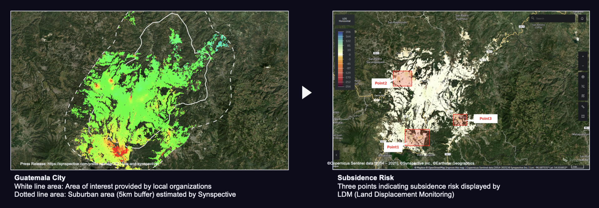 Ground Risk Analysis in Guatemala with JICA, July 2018 – June 2021
In January 2025, during the Los Angeles wildfires, SAR data proved vital for the “React” phase, penetrating thick smoke plumes that blinded optical sensors to map active fire fronts and identify at-risk neighborhoods in real-time. Similarly, following the Myanmar earthquake in March 2025, SAR’s capabilities allowed for rapid damage assessment in remote regions, detecting surface shifts and structural collapses before ground teams could reach the epicenter.
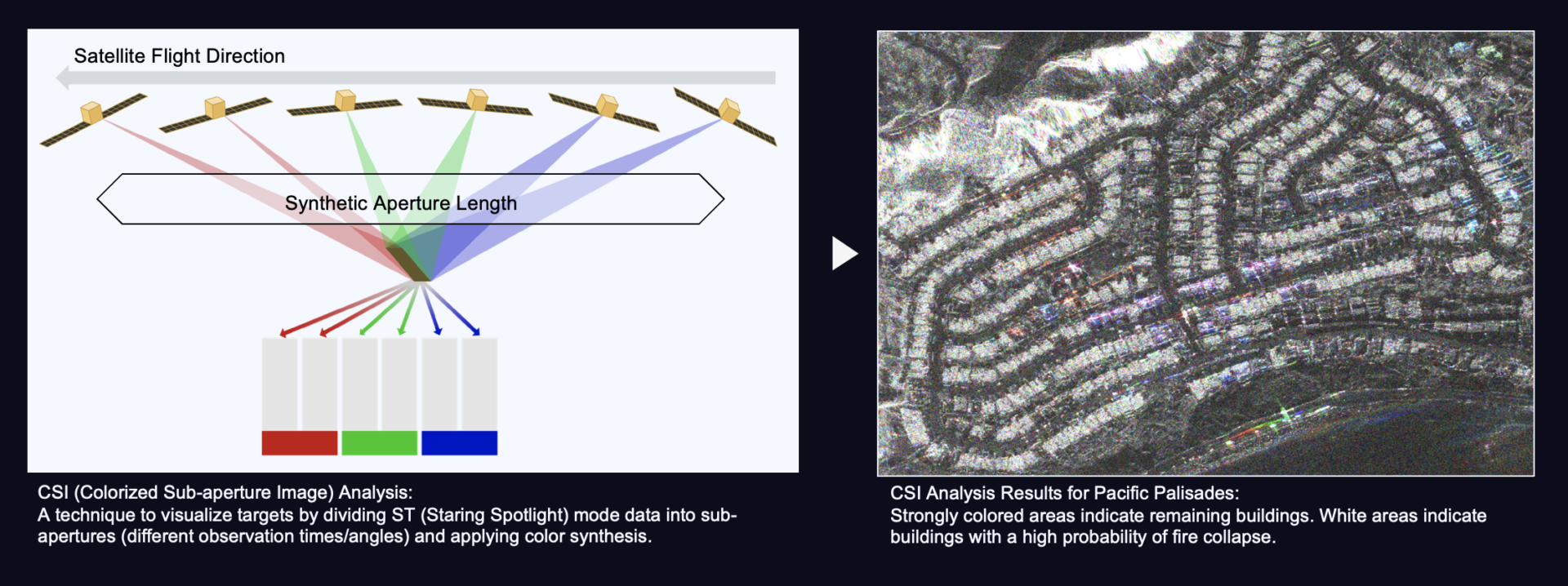 Building Collapse Detection in the Los Angeles Wildfire, January 2025
The technology to support all three phases of disaster resilience is largely in place. What is still being developed is the business model that makes it accessible to state and local governments that need it most. Most of these agencies have limited familiarity with SAR specifically. What matters to them is actionable analytics, including flood damage assessment, wildfire tracking, and infrastructure monitoring, delivered with the right licensing terms so they can share results across agencies and with first responders. Subscription models that can be activated before an event rather than during one are part of the answer. Upfront education on licensing will also be prudent, because the cost of getting that wrong in the middle of a disaster is too high.
There is no single model being used effectively today across the full prepare, react, and recover cycle. That gap is also the opening.