

Summary
Aging social infrastructure and large-scale energy facilities are driving demand for remote monitoring. Satellite observation offers several approaches, but no single method is universally applicable. The appropriate technology depends on the scale of the target’s displacement and the environmental conditions under which it operates.
This article presents a high-precision monitoring method that combines high-resolution data from Synspective’s StriX SAR satellite with the Pixel Offset (PO) method. The combination suits infrastructure that moves by several meters, a scale at which conventional interferometric techniques break down. An observation campaign at the floating-roof oil tank farm at Cushing, Oklahoma illustrates how to match SAR technology to the target.
Background
Plants, pipelines, dams, and mining sites face ongoing risks of land subsidence and structural deformation. Inspecting these assets is labor-intensive and in many cases hazardous. Workforce constraints and safety considerations are pushing operators toward satellite-based remote monitoring.
Challenge: Matching the Method to the Target
No single technology covers every infrastructure monitoring task. The right method depends on how much the target moves and the conditions under which it is observed.
Optical satellites and drones provide visual, intuitive imagery but cannot observe through clouds or at night, which limits their reliability for continuous monitoring.
Interferometric SAR (InSAR) uses phase differences in the radar signal to detect surface changes at millimeter scale and is the standard method for subsidence and slow structural deformation. Its limitation is decorrelation: when a target moves several meters in a short period, as operating tank roofs do, the phase relationship between observations breaks down and the analysis fails.
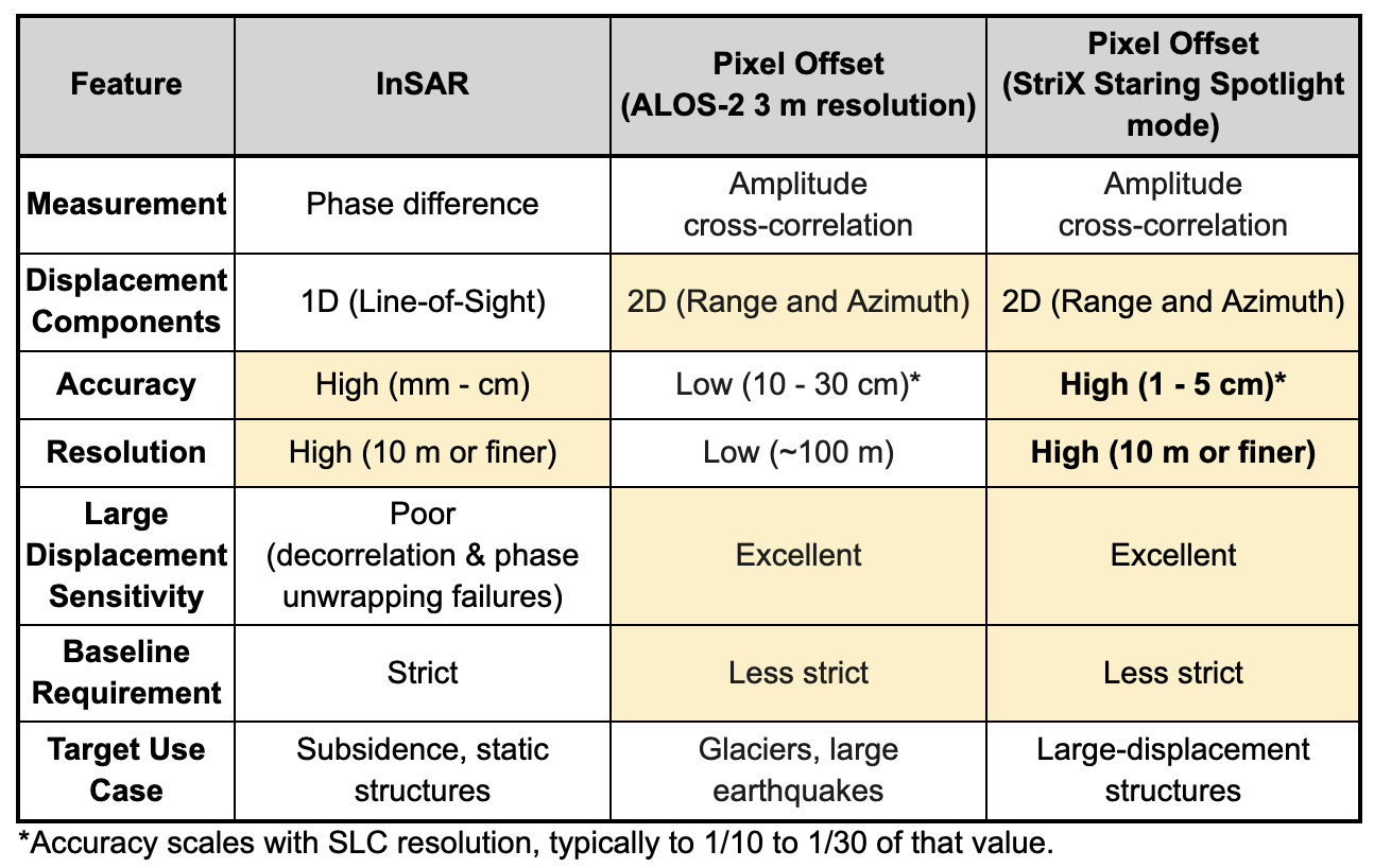
The Pixel Offset (PO) method measures the shift in image amplitude between observations. Because it does not rely on phase, it handles meter-scale displacement without decorrelating. Accuracy has historically been its weakness, but StriX’s sub-0.5 m resolution lifts PO accuracy into the 1 to 5 cm range, comparable to InSAR.
Solution: Pairing StriX Resolution with the PO Method
The Pixel Offset (PO) method is the appropriate technique for displacements that exceed InSAR’s working range. It compares two images and measures the shift in pixel amplitude between them, which allows it to track motion on the order of meters without the decorrelation that disables InSAR at this scale.
PO accuracy scales with image resolution. Earlier-generation SAR data produced errors of several tens of centimeters, which limited the method to coarse estimation. StriX’s sub-0.5 m resolution changes that trade-off. The method retains its robustness to large displacement, and measurement accuracy now reaches 1 to 5 cm, close to what InSAR delivers for slow deformation.
Floating-Roof Tank Monitoring at Cushing
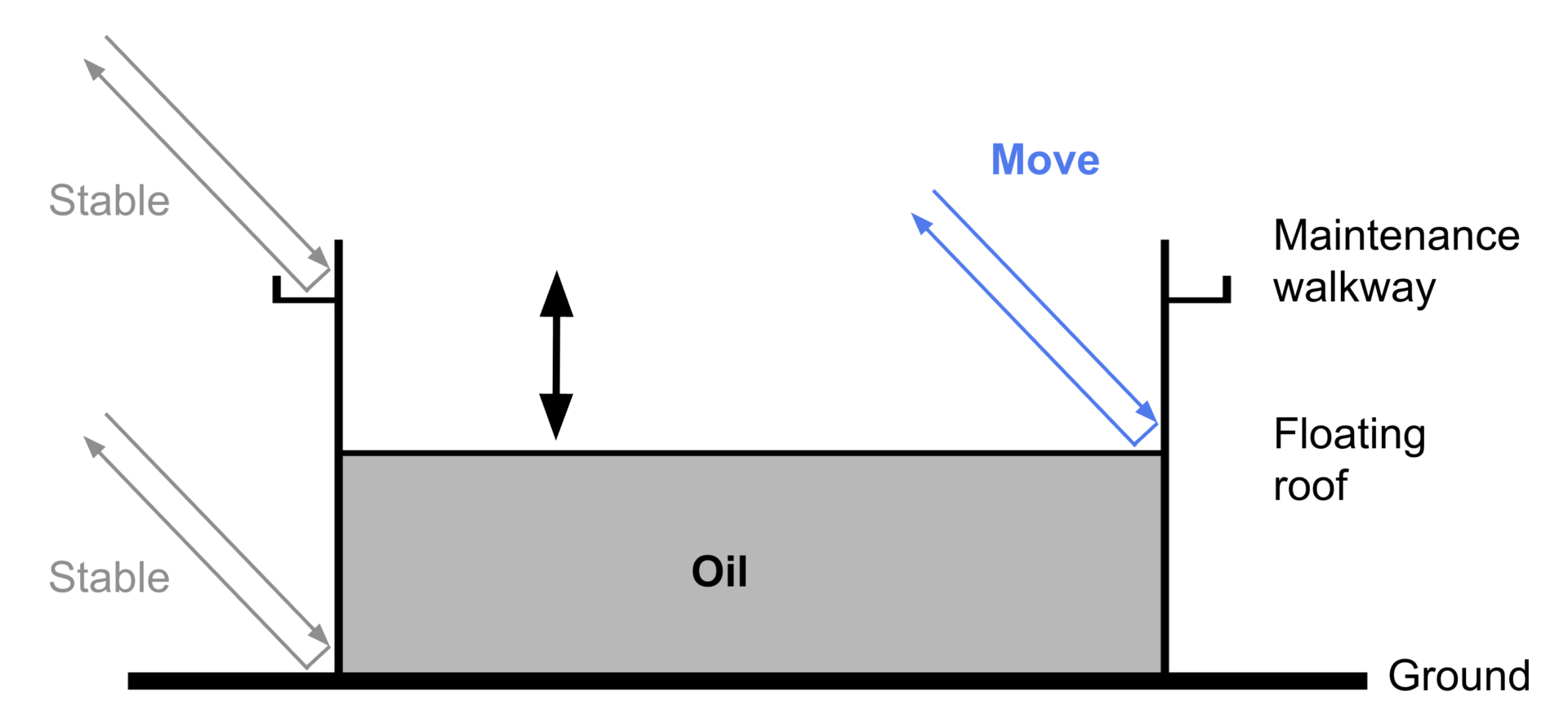
Cushing, Oklahoma is the physical delivery point for West Texas Intermediate (WTI) crude oil and one of the largest storage terminals in the world. Many of its tanks use floating-roof construction, where the roof sits directly on the stored crude and rises or falls by several meters as the tank fills or empties. This makes Cushing a suitable test site for the high-resolution PO method: the targets move in meter-scale increments that would defeat InSAR, and the changes are frequent enough to test the method under operational conditions.
Synspective conducted an observation campaign at Cushing from November 2025 to January 2026. Two aspects of the campaign are worth noting.
High-frequency continuous observation: StriX observed the terminal on a cycle shorter than one day, capturing the vertical roof movements that accompany fueling and draining.
Multi-angle accuracy evaluation: Four independent observation directions were analyzed and cross-referenced against theoretical noise estimates to assess whether the method is reliable enough for operational use.
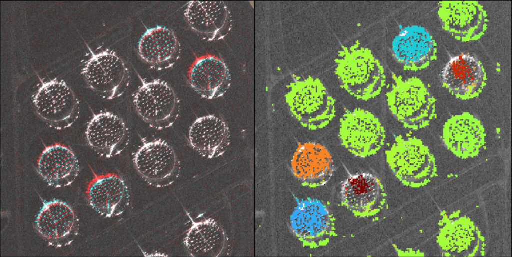
Results: Centimeter-Level Agreement Across Four Observation Directions
The campaign produced data from four observation geometries, combining ascending and descending orbits with right-looking and left-looking acquisitions. Each dataset was processed independently, yielding displacement time series for individual tank roofs.
Example of Range Offset
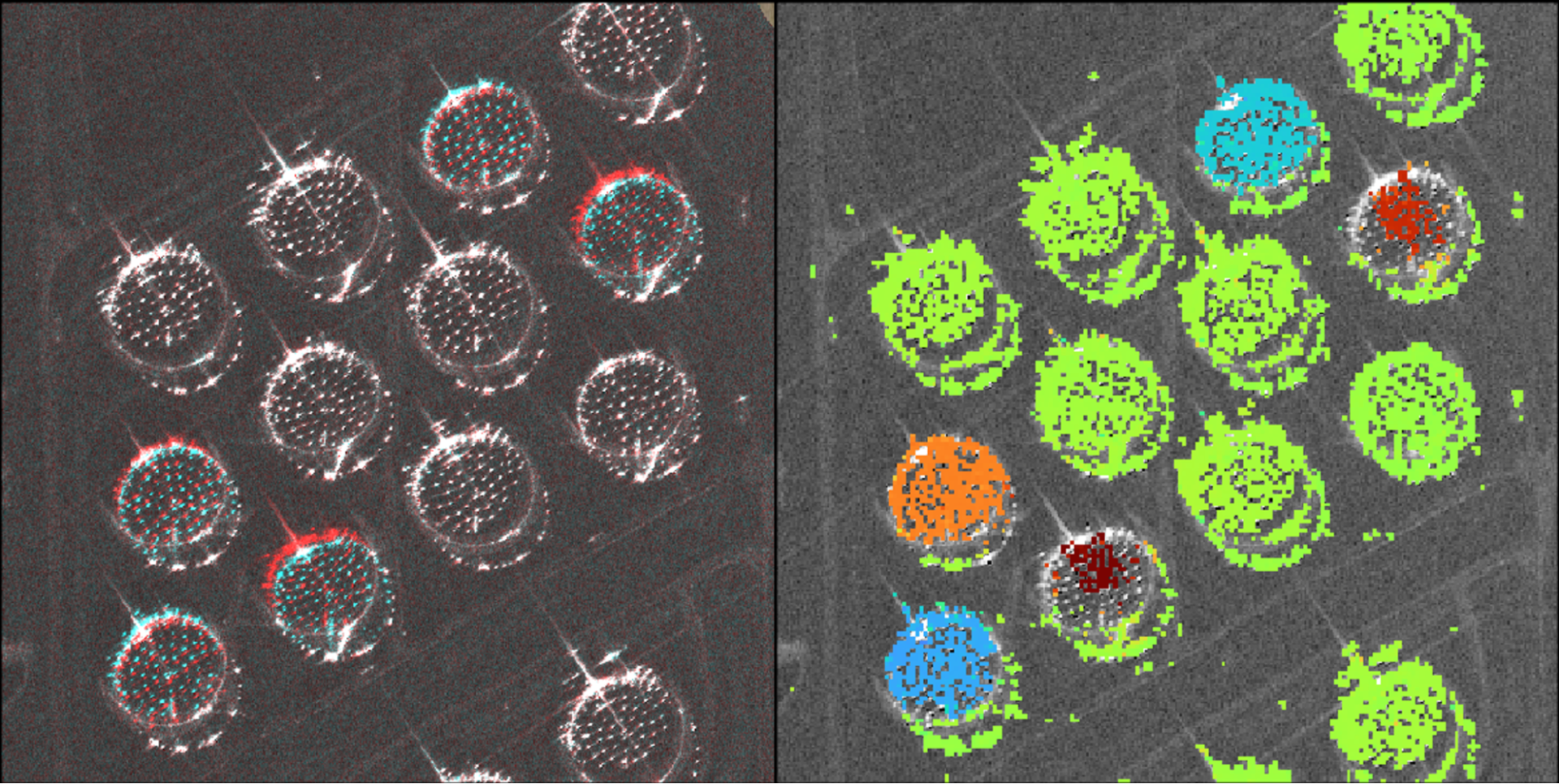
Time-Series Range Offset from Four Observation Directions
Red/Orange: Rising (Storage increase) | Blue/Purple: Falling (Storage decrease)
Vertical Displacement Time Series
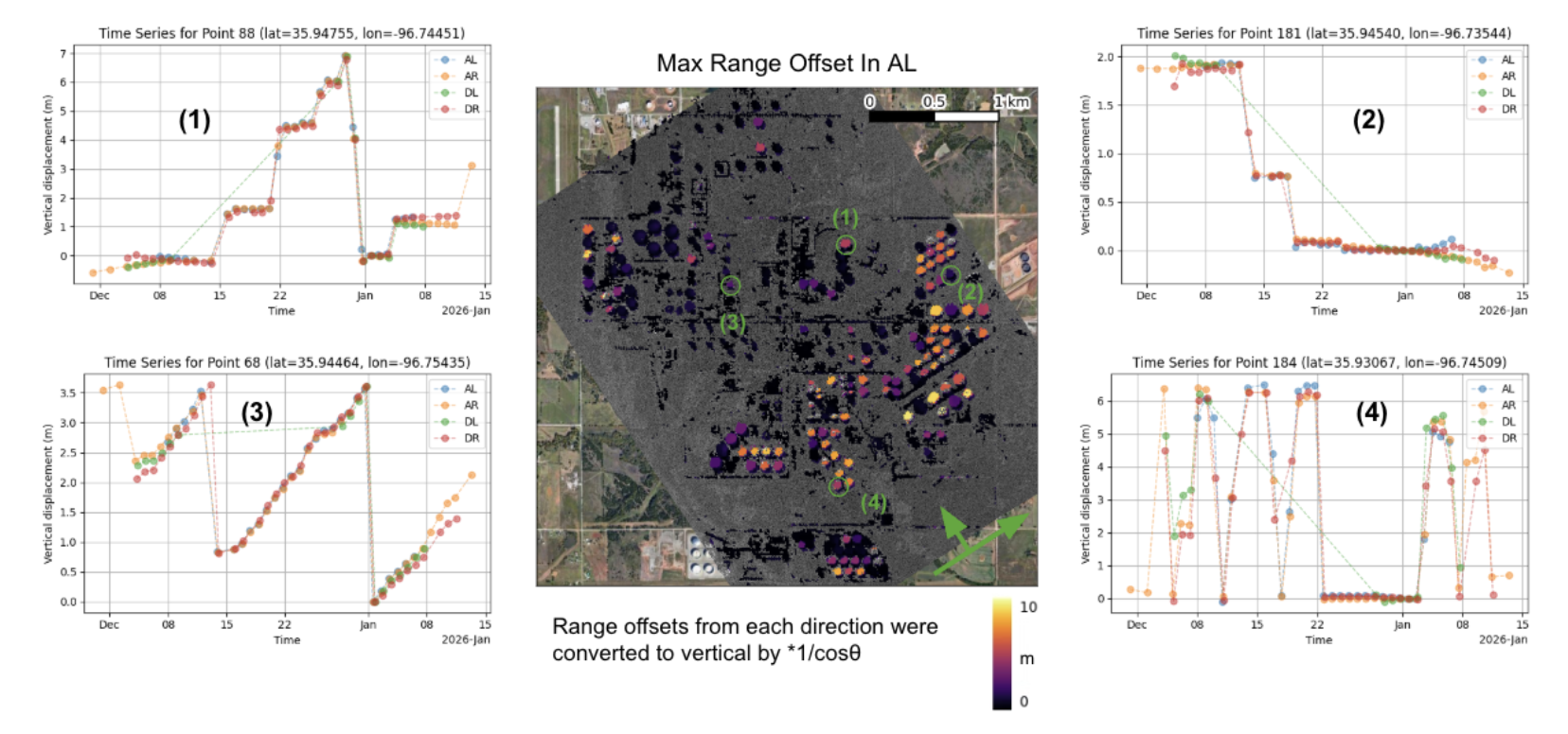
Vertical displacement estimates from the four observation directions agreed closely. When the line-of-sight measurements were converted to the vertical, the independent results from different orbits and look directions matched to within centimeters. This cross-directional agreement is strong evidence for the reliability and accuracy of the method.
A second evaluation compared analytical residuals against the theoretical uncertainty budget. For many tanks, the correlation between the two was 0.7 or higher, and the root-mean-square (RMS) of the residuals fell below 5 mm. Together, these results demonstrate that the method can support automated, high-accuracy inventory monitoring of large oil storage facilities from orbit.
Future Outlook
Infrastructure monitoring works best when the technique is matched to the target. InSAR remains the right choice for slow, millimeter-scale deformation, and the high-resolution PO method extends the reach of SAR-based monitoring to the meter scale, where InSAR fails. Together, they cover a range of applications that no single technique can address alone.
The Cushing demonstration shows what the PO method can do for floating-roof tanks, but the same approach applies to any individual constructed structure whose displacement unfolds on a similar scale. Localized lateral flow affecting buildings, port facilities, and other constructed assets is one obvious extension. When the Synspective constellation reaches its planned size of more than 30 satellites, the cadence of observations at any given site will increase to several per day, enabling continuous, method-appropriate monitoring of infrastructure worldwide.
Reference
Observation Mode: Staring Spotlight 4 (resolution 0.46 m x 0.25 m).
The three methods apply to different situations:
- InSAR: slow, millimeter-scale deformation such as subsidence or static structural settling.
- PO method with conventional SAR data: large displacements at coarse accuracy (errors of tens of centimeters).
- PO method with high-resolution StriX data: meter-scale displacement of individual constructed assets, at centimeter accuracy and roughly 10 m spatial resolution.
Author’s information
Dr. Yu Morishita is Principal SAR Application Engineer at Synspective. Before joining in 2022, he was Chief Researcher at the Geospatial Information Authority of Japan (GSI) and a visiting researcher at the University of Leeds. He is the developer of LiCSBAS, an open-source InSAR time-series analysis toolkit, and has published on pixel offset methodology and surface deformation measurement.