

Summary
For tunnel work and road maintenance in mountainous terrain, monitoring slope movement and ground deformation across the full slope is fundamental to safety. Conventional in-situ measurements read at specific points with high precision, but they have limited ability to provide an overview of an entire slope, including stretches where no instruments are installed.
This article presents a ground deformation monitoring case carried out with Okuyama Boring Co., Ltd., a firm specializing in geological survey and slope disaster prevention. By combining data from JAXA’s ALOS-4 and ALOS-2 satellites, which carry an L-band Synthetic Aperture Radar (SAR) suited to wide-area observation, with advanced interferometric techniques (Phase Linking and 2.5D analysis), we obtained full-slope displacement measurements in close agreement with the field data.
Background
In the survey area along the national highway, where the challenge is to understand landslide risk in detail, observations have to capture not just specific points but also the ground deformation of the entire slope, across a wide area and over time.
The instruments installed record displacement at their locations continuously and with high precision. But what they observe is a single point. They cannot survey the movement at locations without instruments, or the behavior of the slope as a whole. A method was urgently needed to complement those point readings and capture the movement of the entire slope as an area.
Challenge: Capturing Wide-Area, Multi-Directional (3D) Displacement
The leading way to extend point observation to the full slope is SAR data analysis, meaning interferometric SAR analysis of satellite imagery. But applying it to a landslide site raised two technical challenges.
The first is reading the direction of displacement. Standard SAR interferometry captures movement only along the line of sight between satellite and ground, a single dimension. In a landslide area with complex geology and terrain, though, you have to separate cleanly whether the ground is settling (vertical) or moving downslope (horizontal).
The second is vegetation noise. The vegetation characteristic of mountainous terrain destabilizes the radar return and degrades analytical precision. Stable, high-precision analysis over a wide area required a means of suppressing it.
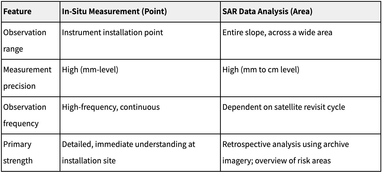
Field measurement (point) and SAR data analysis (area) have distinct strengths and complement each other.
Solution: Combining Phase Linking Analysis with 2.5D Analysis
To address these challenges, Synspective applied two advanced analysis techniques in combination.
> Handling vegetation noise — Phase Linking (PhL) analysis
Phase Linking is a high-precision time-series interferometric technique that statistically processes a stack of SAR images to reduce noise and increase the number of pixels that return stable displacement. This makes reasonably stable measurement possible even on vegetated ground and other land cover that has been difficult to analyze, so the entire slope can be read at higher precision.
> Separating displacement direction — 2.5D analysis
For this project we went further, running a 2.5D analysis that combines results from ALOS-4 and ALOS-2 observed from two directions: the ascending orbit (viewed from the west) and the descending orbit (viewed from the east). This makes it possible to separate and compute vertical from east-west (horizontal) displacement, which a single orbit cannot do, and gives a three-dimensional reading of the landslide’s movement that distinguishes vertical displacement from the direction of horizontal movement.
For this analysis, we selected 14 image pairs suited to interferometry from ALOS-2 and ALOS-4 acquisitions between 2014 and 2025. Winter images (December to March), affected by snow cover, were excluded. Working from data taken under consistent observation conditions, we captured a stable record of long-term displacement trends spanning roughly ten years.
Results: High-Precision, Full-Slope Detection of Displacement Consistent with Field Data
The analysis clearly captured the fine movement around the landslide blocks, and the results agreed closely with the field data Okuyama Boring measured on site.
Figure 1. Full-slope distribution of cumulative vertical displacement from 2.5D analysis (based on 2014–2025 time-series data). A subsidence trend of roughly 100 mm over about ten years around the landslide blocks on both banks (indicated by arrows).
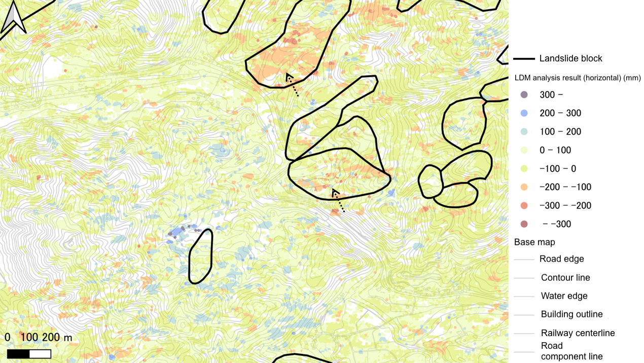
Created from Geospatial Information Authority of Japan (GSI) Fundamental Geospatial Data and National Research Institute for Earth Science and Disaster Resilience (NIED) Landslide Topography GIS Data. © JAXA [2014–2025], © Synspective Inc.
Figure 2. Full-slope distribution of cumulative horizontal displacement from 2.5D analysis (based on 2014–2025 time-series data). Around the landslide blocks on both banks, the right bank moved westward by roughly 40 to 100 mm over about ten years (indicated by arrows).
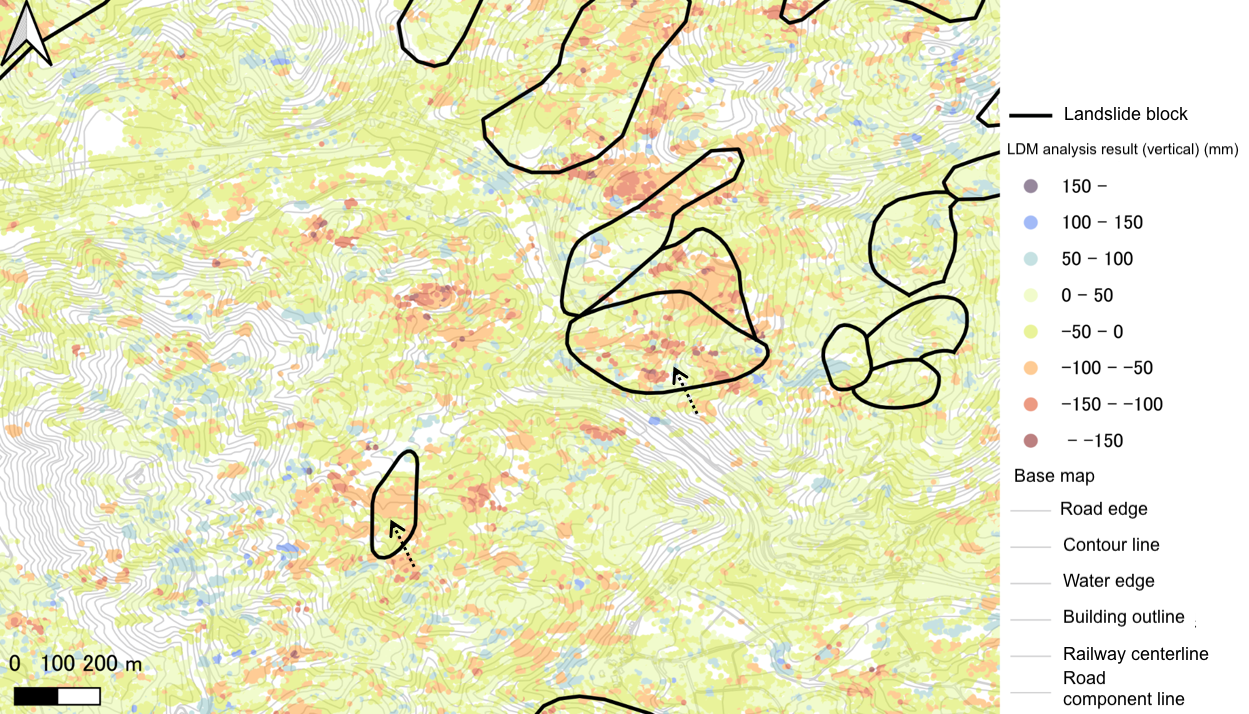
Created from Geospatial Information Authority of Japan (GSI) Fundamental Geospatial Data and National Research Institute for Earth Science and Disaster Resilience (NIED) Landslide Topography GIS Data. © JAXA [2014–2025], © Synspective Inc.
Around the landslide blocks on both banks, we confirmed a subsidence trend of roughly 100 mm over about ten years. Around the right-bank landslide blocks, we also confirmed a westward displacement trend of 40 to 100 mm. The agreement with field data was especially close for the direction of horizontal movement. From these results, the analysis succeeded in capturing accurately and across the full slope the complex displacement that follows the terrain, the structure of the landslide blocks, and the direction of slope inclination.
Future Outlook: Advanced Infrastructure Management through Full-Slope Monitoring from Space
This joint project with Okuyama Boring demonstrates that 2.5D Time-Series InSAR using JAXA’s ALOS-4 and ALOS-2 SAR satellites can provide reliable evidence in real landslide and slope monitoring.
Tying point observation from field measurement closely together with full-slope observation from SAR analysis guards against overlooked risk areas and supports a safer, more efficient framework for infrastructure maintenance. As a JAXA-certified ALOS-4 data service provider, Synspective will continue to draw on that strength and contribute, through high-precision satellite solutions, to advances in disaster prevention and infrastructure management.