©JAXA
Satellite and Sensor Specifications
The Advanced Land Observing Satellite-4 (ALOS-4), also known as “DAICHI-4,” is JAXA’s successor to ALOS-2. It carries the state-of-the-art PALSAR-3 (Phased Array type L-band Synthetic Aperture Radar-3).
The key advantage of ALOS-4 lies in its L-band (approx. 1.2 GHz / 24cm wavelength) microwaves. Unlike X-band or C-band, L-band microwaves can penetrate the forest canopy to reach tree trunks and branches. This capability makes it extremely effective for biomass estimation and deforestation detection.
L-band data maintains high coherence over longer periods, even in vegetated areas, making it the global standard for Interferometric SAR (InSAR). This allows for precise, millimeter-level measurement of land displacement, crustal deformation, land subsidence, and infrastructure stability.
Key Satellite Specifications
| Orbit | Sun-synchronous |
| Altitude | 628 km |
| Revisit Time | 14 days |
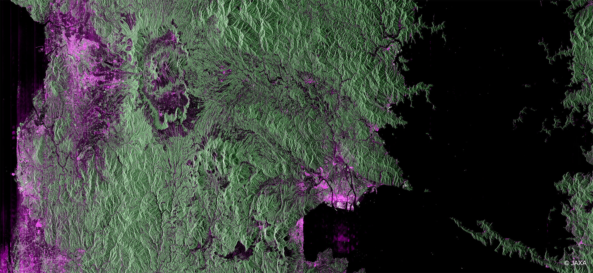
Land Cover Visualization via Polarimetric Color Composite
Acquired by ALOS-4 in April 2025, this image captures the Kyushu-Kumamoto region. Spanning from downtown Kumamoto to the Aso Caldera, it demonstrates the capability to image a vast 200km swath in a single pass. Through polarimetric color composition, the image clearly contrasts vegetation (green) with urban areas (purple/pink), highlighting the satellite’s power in distinguishing land cover and terrain details.
Observation Modes
Observation Modes PALSAR-3 (ALOS-4) provides three primary observation modes, allowing you to select the ideal balance of resolution and observation area for your specific application.
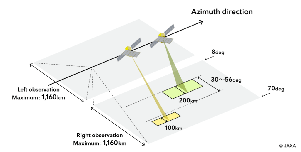
Stripmap (High-Resolution)
This standard observation mode achieves an unprecedented combination of high resolution (down to 3m) and an exceptionally wide swath of 200km. This allows for high-detail monitoring of large areas, vastly improving response times for disaster management and regional monitoring.
| Ground Range Resolution | 3m, 6m, 10m |
| Nominal Swath Width | 100 km, 200 km |
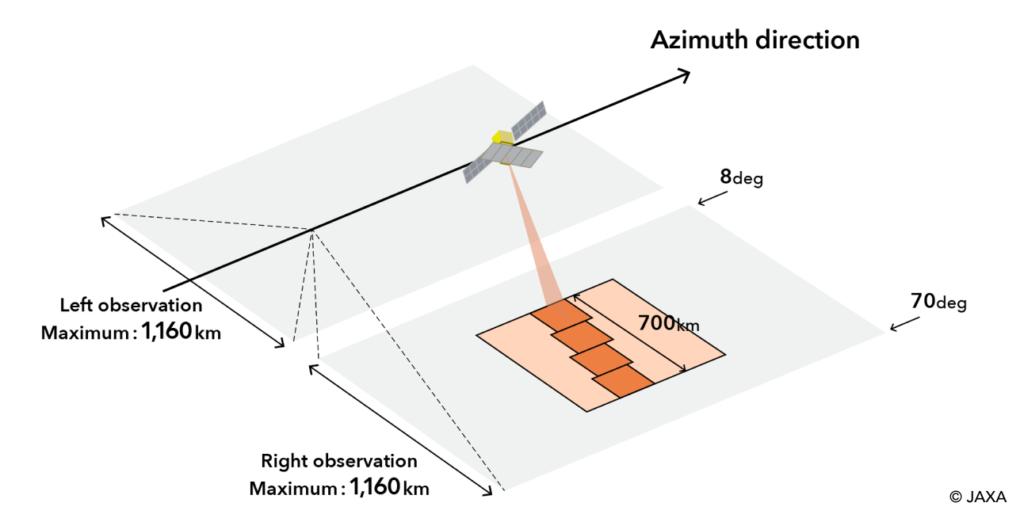
ScanSAR (Wide-Area)
By scanning the beam, ScanSAR mode achieves an extremely wide observation swath of 700km. This is ideal for broad-area mapping, such as monitoring sea ice, maritime activity, or assessing the extent of large-scale disasters like floods and wildfires.
| Ground Range Resolution | 25m |
| Nominal Swath Width | 700 km |
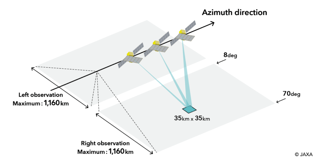
Spotlight
In this mode, the antenna beam is steered to focus on a specific, smaller target area for a longer duration. This achieves the highest possible resolution (1m x 3m), perfect for detailed site monitoring, infrastructure analysis, and target recognition.
| Ground Range Resolution | 1m x 3m |
| Nominal Swath Width | 35 km |
Technical Note: The observable range is 1160 km to both the left and right (in the cross-track direction), corresponding to an incidence angle of 8° to 70°. Observation in the standard high-resolution mode features a right-looking observation, a 200 km swath width, and an incidence angle of 30° to 44°.
How to purchase ALOS-4 Data
Get Started with ALOS-4
Looking to leverage the power of L-band data? Our team can help you identify the right data for your organization. Contact us for product guides, acquisition details, and to discuss your project.
Technical Documentation
Technical Documentation: To learn more about specific ALOS-4 data products, processing levels, and file formats to prepare for your analysis, see the official JAXA documentation.