

Summary
Routine monitoring in the infrastructure and environmental sectors places a heavy burden on local governments. The safety management of embankments scattered across wide areas is especially pressing, where staffing and budget constraints make greater efficiency urgent.
As part of Saga Prefecture’s fiscal 2025 Demonstration Project on the Potential Applications of Satellite Data, Synspective formed a joint venture with the construction consultancy Fujiyama Co., Ltd. to demonstrate embankment and terrain-change monitoring that fuses ESA’s optical satellite Sentinel-2 with JAXA’s L-band synthetic aperture radar (SAR) satellites ALOS-2 and ALOS-4, both built for wide-area observation. By combining free satellite data with machine learning, the new solution extracted change sites that conventional methods had failed to capture and pointed to expected cost reductions of more than 50 percent compared with conventional surveys.
Background
Recent embankment-related disasters have prompted calls for stronger embankment safety management among local governments nationwide. In Saga Prefecture as well, the identification and assessment of embankments has been carried out as part of a baseline survey under the relevant legislation.
However, continuously tracking embankments scattered across wide areas with limited budgets and staff is a heavy burden for local governments. Establishing a lower-cost, more comprehensive screening method to replace conventional approaches that rely on field surveys and commercial satellite imagery had become an urgent priority.
Challenge: Resolving the Trade-Off Between Cost and Comprehensiveness
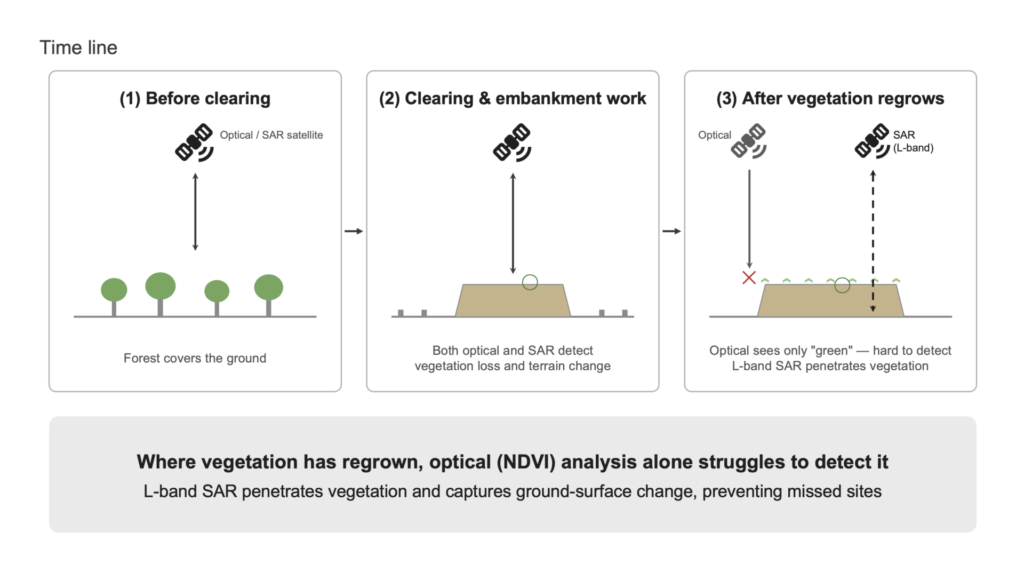
Conventional methods relied on expensive high-resolution satellite imagery, which incurred steep image costs. On top of that, obtaining images suited to the analysis conditions took time, as newly tasked images could turn out to be obscured by clouds, and costs stayed persistently high. These optical imagery methods were also prone to false positives and missed detections, and what was needed was a new screening method that could deliver both a substantial cut in survey costs and the comprehensiveness and accuracy needed to keep change sites from being overlooked. Optical satellites alone struggle, particularly where low vegetation has regrown after clearing, leading to change sites being missed.
Solution: A Three-Layer Architecture Combining Free Optical Data, Commercial SAR Data, and Machine Learning
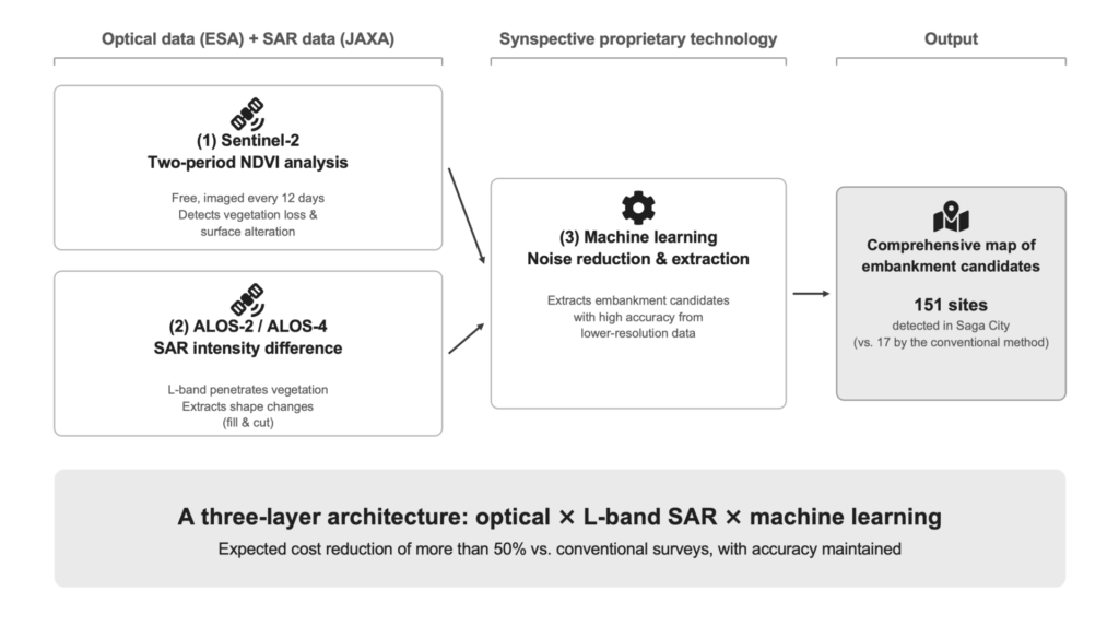
Synspective partnered with the construction consultancy Fujiyama in a joint venture to design and demonstrate a new solution that combines three technologies.
- Two-period NDVI analysis with Sentinel-2 (optical): Sentinel-2, which ESA images on a regular 12-day cycle and releases free of charge, provides data for tracking changes in the Normalized Difference Vegetation Index (NDVI) and detecting vegetation loss and surface alterations caused by embankment work. Its deep image archive and free access sharply reduce the labor and cost of image selection.
- SAR intensity-difference analysis with ALOS-2 and ALOS-4: Physical changes in the shape of the land surface, such as fill and cut, that optical data alone struggles to capture are extracted through SAR intensity-difference analysis, which compares intensity images from JAXA’s L-band SAR satellites ALOS-2 and ALOS-4 over time. SAR is largely unaffected by cloud cover or vegetation, and the L-band, in particular, is effective at detecting embankment sites even after vegetation has regrown. As a JAXA-certified ALOS-4 data service provider, Synspective delivers cost-efficient analysis drawing on the latest ALOS-4 data.
- Machine learning for noise reduction and extraction: Free satellite data is lower-resolution than the commercial optical imagery it replaces, but a machine learning algorithm developed in-house by Synspective extracts candidate embankment sites from this lower-resolution data with high accuracy. Combining these three technologies achieved a substantial cost reduction while maintaining accuracy.
Results: Extractions Expanded from 17 to 151 Sites, with Expected Cost Reductions of More Than 50 Percent
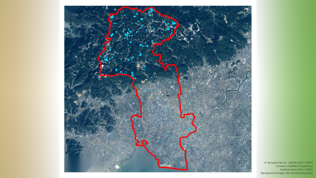
When tested in Saga City, Saga Prefecture (about 431 square kilometers) from 2017 to 2025, the new solution far outperformed conventional methods.
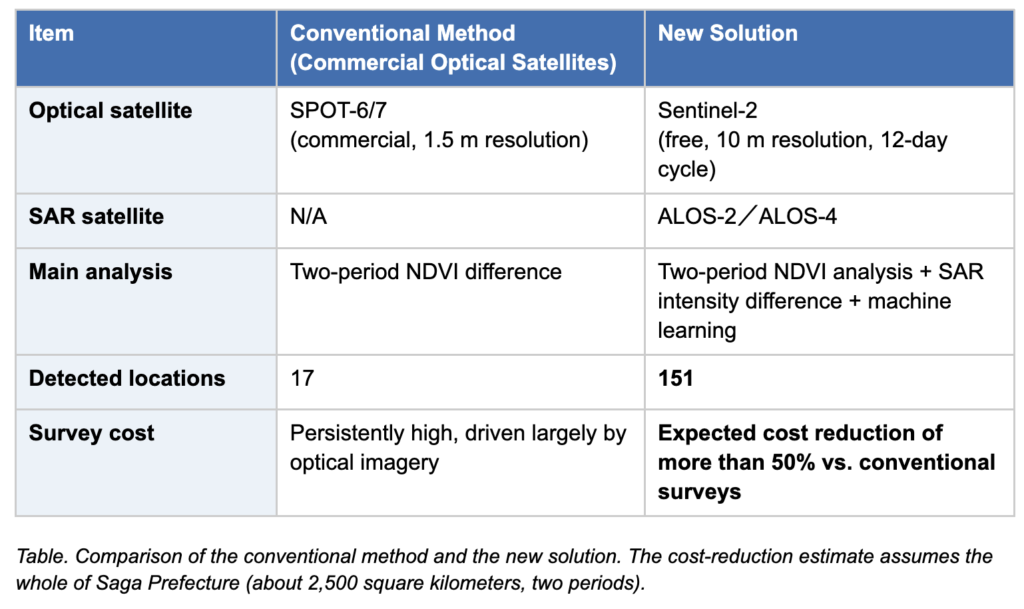
- Greater comprehensiveness (17 to 151 sites): The new method reproduced 15 of the 17 sites identified by the current method and detected about 130 changes the current method had missed, for a total of 151 sites. Using optical (Sentinel-2) and SAR (ALOS-2 and ALOS-4) together captures shape changes even where vegetation has regrown, sharply reducing missed detections.
- Cost reductions of more than 50 percent: Replacing commercial optical imagery with free Sentinel-2 data and drawing on the latest ALOS-4 data, an estimate for the whole of Saga Prefecture (about 2,500 square kilometers) showed that the new solution meets that threshold compared with conventional surveys. The savings grow as the target area widens, which markedly improves the sustainability of continuous monitoring by local governments.
Future Outlook:
The demonstration showed that wide-area, low-cost screening with satellite data is a highly effective tool for sustainable infrastructure management by local governments.
At the same time, gradual changes, such as a clearing that widens slowly over time, remain difficult for the current algorithm to detect in some cases. Going forward, incorporating an algorithm that also weighs the NDVI difference between the start and end of the target period will further sharpen the accuracy of extracting these change sites.
Drawing on its expertise as an ALOS-4 data service provider, Synspective will continue to advance the real-world deployment of more efficient, more reliable satellite monitoring solutions attuned to the challenges facing local governments and infrastructure managers.