

![]()
Press release
December 7, 2021
Japan International Cooperation Agency, Central and South America, Caribbean Division
Japan International Cooperation Agency, Guatemala Office
Synspective Inc.
JICA and Synspective detect new risks in Guatemala using SAR satellite data The development of a disaster prevention management system makes progress
Japan International Cooperation Agency (JICA) and Synspective started a satellite use service demonstration to monitor ground movements in Guatemala City, Guatemala, as part of an information gathering and pilot project.
Using “Land Displacement Monitoring” (LDM), a ground deformation monitoring service using satellite data provided by Synspective, we conducted a ground deformation analysis for approximately three years (July 2018 to June 2021) in Guatemala City and its suburbs.
Press Release: “JICA and Synspective start demonstration for the development of a disaster prevention management system in Guatemala using SAR satellite data”
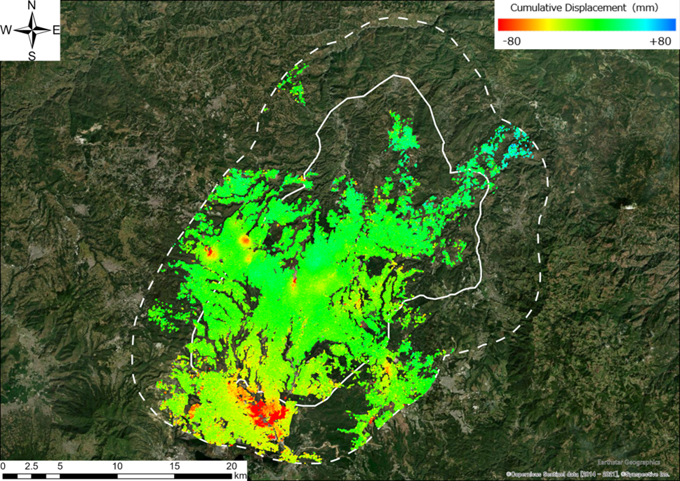
■Overall trends
As a general trend in Guatemala City, we have identified localized subsidence phenomena and areas that show sinkage and landslide risks. The figure below shows that the maximum subsidence area fluctuated by about -292mm and the maximum uplift area fluctuated by about +88mm.

©Copernicus Sentinel data [2014 – 2021], ©Synspective Inc., ©Earthstar Geographics
Figure 1: LDM Analysis Results
*Solid white line: area of interest provided by counterpart *1
*Dotted line: estimated suburban area (5km buffer)
■New subsidence risk detection
Detailed analysis of the points that showed characteristic fluctuation trends revealed that three points (red points 1 to 3) were new sinkage risk points that had not been confirmed by conventional survey methods*2.

Figure 2: An image from Synspective’s LDM service showing the risk of subsidence at 3 point locations
*1 Counterpart: persons or institutions in charge of site as it pertains to international collaboration and cooperation
*2 Traditional surveying methods for land hazards — In the past, the amount of ground deformation was not measured using satellites, and the counterpart agency staff went to the site as an after-the-fact response when a landslide or other disaster occurred. In addition, risk assessment was conducted using indirect indicators such as landslide inventory based on existing topographical and rainfall information.
■Faster, wider coverage with easy-to-understand information
This wide-area analysis using satellite data has shown that it is possible to extract new ground deformation and sinkage risks. In addition, the time from analysis to provision of data has been reduced to about 1/3 of the time of conventional methods (compared to our company) due to automatic analysis. The new discoveries made by satellite data and the speedy provision of analysis results are expected to lead to faster implementation of preventive maintenance measures for disaster prevention and mitigation.
■ Next Steps
In this demonstration project, the LDM will be used by counterpart organizations to evaluate the simplicity, efficiency, and effectiveness of the system. LDM enables easy acquisition of analysis results from SAR satellites and provides analysis results on an easy-to-understand screen display on the web, without requiring environmental equipment such as specialized software or advanced technical knowledge. In terms of functions, the ability to zoom in on the area of interest and automatically create graphs allows for detailed data confirmation and analysis. After evaluating the effectiveness of the system, we plan to contribute to disaster prevention projects in Guatemala.
■Synspective Inc.
Synspective provides one-stop solutions using geospatial data from its own SAR satellites, upon its mission to create a progressive world based on real data. The core technology was developed by the ImPACT program led by The Cabinet Office, Government of Japan. Synspective is building a constellation of its own small SAR satellites to provide its data and analytic information to governments and commercial outfits.
Founded: February 22, 2018
Location: 3-10-3 Miyoshi, Koto-ku, Tokyo
Representative: Motoyuki Arai, CEO
URL: https://dev.synspective.com/stargazer/
■JICA: Japan International Cooperation Agency
Japan International Cooperation Agency (JICA) is the executing agency that centrally provides Japan’s Official Development Assistance (ODA) to developing countries for socioeconomic development. JICA’s organizational vision is to “lead the world with trust.” JICA has 96 overseas offices and 14 domestic offices. The organization provides assistance in fields such as disaster prevention, education, health care, agriculture and rural development, working in over 150 countries and regions.
Founded: October 2003
Location: Nibancho Center Building, 5-25 Niban-cho, Chiyoda-ku, Tokyo
Representative: Shinichi Kitaoka, President
URL: https://www.jica.go.jp/index.html
<Contact>
Synspective PR