

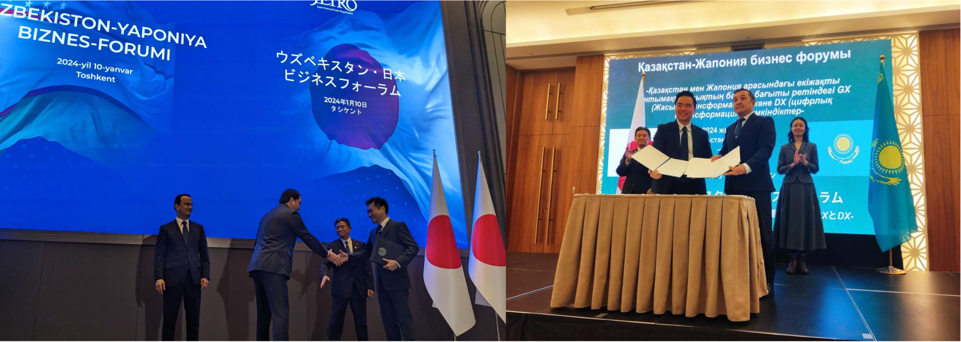
Tokyo, Japan – Synspective, a SAR satellite data and analytics solution provider, today announced that it is entering into memoranda of understanding (MOUs) with Uzbekistan’s Center for Space Monitoring and Geoinformation Technologies and Kazakhstan Gharysh Sapary (KGS), the national space agency of Kazakhstan. In early January, along with key ministry officials from Uzbekistan. Kazakhstan and Japan, attended the MOU ceremonies held in both countries.
Monitoring for potential identification of seismic risks in Uzbekistan:
This collaboration in Uzbekistan is designed to carry out research and development for risk evaluation using interferometric Synthetic Aperture Radar (InSAR) technology*. Previous large-scale earthquakes and landslides in Uzbekistan and nearby areas have highlighted the pressing need for predicting and managing land disasters. SAR, an advanced technology capable of yielding high-resolution imagery of the Earth’s surface, is crucial for monitoring land displacement. This could aid in the potential identification of seismic risks in Uzbekistan, thereby aiding in disaster preparedness and mitigation.
* Interferometric Synthetic Aperture Radar (InSAR) is a technique for mapping ground deformation using radar images of the Earth’s surface that are collected from orbiting satellites.
Seeking Innovative Applications of Earth Remote Sensing in Kazakhstan:
Synspective and KGS in Kazakhstan will initially focus on developing new applications for Earth remote sensing and radar data, especially in disaster management, including the mitigation of landslides, mudflows, floods, and effective infrastructure management to reduce the impacts of climate change. Additionally, this collaboration opens avenues for joint international commercial projects, enabling Synspective to capitalize on its satellite data and analytics solutions. Concurrently, it offers KGS the opportunity to enhance its technological capabilities and explore further potentials of this emerging technology.
Motoyuki Arai, the founder and CEO of Synspective, commented on these partnerships saying, “Partnering with Uzbekistan’s Center for Space Monitoring and Geoinformation Technologies and the KGS in Kazakhstan marks another step forward in our mission to make SAR data accessible and beneficial across various global industries for challenging social issues with partners. We will contribute to building resilient infrastructure and promote the efficient and secure use of natural resources and energy in Central Asia and Japan, while consistently improving our technologies to support these initiatives. Furthermore, by expanding our network and exchanging experiences, we are moving forward to achieve a sustainable future with our partners.
Mr Aliyev Soibjon, Director of Center for Space Monitoring and Geoinformation Technologies, Uzbekistan, says:
The mutually beneficial strategic partnership established in recent years between the two countries serves as a favorable basis for the further expansion of bilateral cooperation in many sectors, including in the field of space technology.
We are pleased to note that one of the striking examples of successful bilateral interaction is the cooperation established with the company Synspective Inc.
Mr. Aidyn Aimbetov, Chairman of the Board of JSC «National Company «Kazakhstan Gharysh Sapary», also commented:
The accumulated experience of Kazakhstan’s specialists in radar technologies will allow us to begin new projects with the Japanese company Synspective. Joint cooperation and the use of Japanese advanced technologies and the potential of Kazakhstan can be the main solution for the successful implementation of these projects.
End
About the Center for Space Monitoring and Geoinformation Technologies, Uzbekistan
The «Center for Space Monitoring and GIS Technologies» under the Uzbekspace agency was formed on May 20, 2022, by the Decree of the Cabinet of the Ministries of the Republic of Uzbekistan.
The Center is officially tasked with implementation of state space monitoring program using Earth Observation data and GIS. The Center operates in the following areas:
– remote sensing of the Earth with the help of satellite devices, reception, storage, processing and transmission of its data;
– provision of services in the space industry;
– implementation of scientific and innovative activities in this area in order to widely attract scientific and innovative technologies to the space sector;
-assistance in improving the efficiency of socio-economic activities of economic sectors, defense and security sectors using space and geoinformation technologies, as well as unmanned aerial vehicles.
About the Kazakhstan Gharysh Sapary (KGS)
Joint Stock Company «National Company «Kazakhstan Gharysh Sapary» was established in accordance with the Decree of the Government of the Republic of Kazakhstan dated March 17, 2005.
KGS was determined by the National Operator of the Earth Remote Sensing Space System of the Republic of Kazakhstan, consisting of high and medium resolution spacecraft KazEOSat-1 (with a resolution of 1 m) and KazEOSat-2 (with 6.5m resolution) to provide space images to individuals and legal entities, as well as the National Operator of the High-Precision Satellite Navigation System to implement the tasks of providing satellite navigation services throughout the territory of the Republic of Kazakhstan.
Starting from 2018 JSC “NC KGS” provides space monitoring service to solve a number of industry-specific tasks of the economy.
About Synspective
Synspective, established in 2018, is an end-to-end SAR satellite data and solution provider with the mission to realize a learning world for people to expand their capabilities and make tangible progress with new data and technologies.
With a SAR satellite constellation that enables high-frequency and high-resolution Earth observation, Synspective delivers satellite data and various solutions that combine SAR and IoT data with machine learning and data science techniques.