

![]()
Tokyo, Japan – Synspective, a Synthetic Aperture Radar (SAR) satellite data and analytics solution provider, entered into an agreement with the National Remote Sensing Department of the Ministry of Natural Resources and Environment of Vietnam and Fujitsu Vietnam. The National Remote Sensing Department monitors natural resources, environmental protection, disaster prevention, socio-economic development, security, and defense. Fujitsu Vietnam, a wholly owned subsidiary of Fujitsu Limited, offers comprehensive, integrated IT, telecommunications, and network solutions. This collaboration aims to advance the application of satellite remote sensing technology in monitoring natural resources and the environment, preventing natural disasters, and fostering economic development in Vietnam.
Actively Utilizing SAR Data for Disaster Preparedness and Economic Development
Vietnam, recognized as one of the most disaster-prone nations in the Asia-Pacific region, annually faces severe challenges due to strong winds, floods, storm surges, and landslides triggered by typhoons and tropical cyclones, resulting in significant damage.
To address these challenges through remote sensing technology, Vietnam is actively enhancing international cooperation and investment in this area. This includes developing systems for image data collection, databases, and applications. The country’s goal is to mitigate the impacts of natural disasters and leverage space science technologies for socio-economic development by 2030. These efforts also aim to support national defense, security, and the management of natural resources and environmental protection.[1] [2] [3]
1: Remote sensing is the method for gathering data about objects and activities from afar, primarily through satellites or aircraft. It involves sensors that detect electromagnetic radiation to monitor and assess environmental and geographical conditions. This enables the analysis and monitoring of the Earth’s surface, supporting various applications from conservation to urban development.
2: Approval of the National Strategy for Remote Sensing and Exploration Development up to 2030, with an outlook towards 2040 (149/QD-TTg)
3: Decision No. 169/QD-TTg 2021 the strategy for the development and application of space science and technology through 2030
Utilizing Space Technology to Serve as a Model for the Japan-ASEAN Region
The MOU was finalized following the APRSAF-29 Space Industry Policy Meeting in Jakarta, Indonesia, in September 2023, with support from the Economic Research Institute for ASEAN and East Asia (ERIA).[4] ERIA conducts policy research focused on developing foundations and business programs within the ASEAN region to foster socio-economic development in Japan and ASEAN through space technology. The initiatives outlined in this MOU will set exemplary cases for creating a new ecosystem in ASEAN by leveraging Japanese satellite data and satellite data platforms.
4. “About ERIA: Established by an agreement among the leaders of 16 East Asian countries—including the 10 ASEAN members, Japan, China, Korea, India, Australia, and New Zealand—ERIA is an international organization dedicated to conducting policy research and advocacy to foster economic integration across East Asia. For more information, visit ERIA’s website.”
From Sharing Knowledge and Experience to Driving Socio-Economic Development in Vietnam
The MOU, effective from 2024 to 2028, is designed to facilitate the exchange of knowledge and expertise in natural resource and environmental monitoring and natural disaster prevention in Vietnam. This collaboration leverages SAR data and analysis solutions from Synspective’s SAR satellite constellation with the comprehensive IT solutions offered by Fujitsu Vietnam to foster the country’s socio-economic development and address societal challenges.
Specific activities under this MOU include ground deformation analysis and monitoring using Synspective’s land displacement monitoring (LDM) solution, developing applications and defining requirements for using SAR satellite data in various regions, and conducting research and data collection on the causes and impacts of natural resource issues. Additionally, the project will assess Vietnam’s monitoring capabilities using the SAR satellite constellation.
A Case Study
Vietnam is grappling with land subsidence and landslides, mainly attributed to groundwater pumping, among other factors, heightening the risk of flooding. Notably, the Central Highlands are experiencing an increase in cracks in wallsand soil, a phenomenon also being reported in numerous other areas. These ground fissures often serve as early indicators of potential landslides, likely triggered by the soil becoming saturated and losing strength due to continuous heavy rainfall.
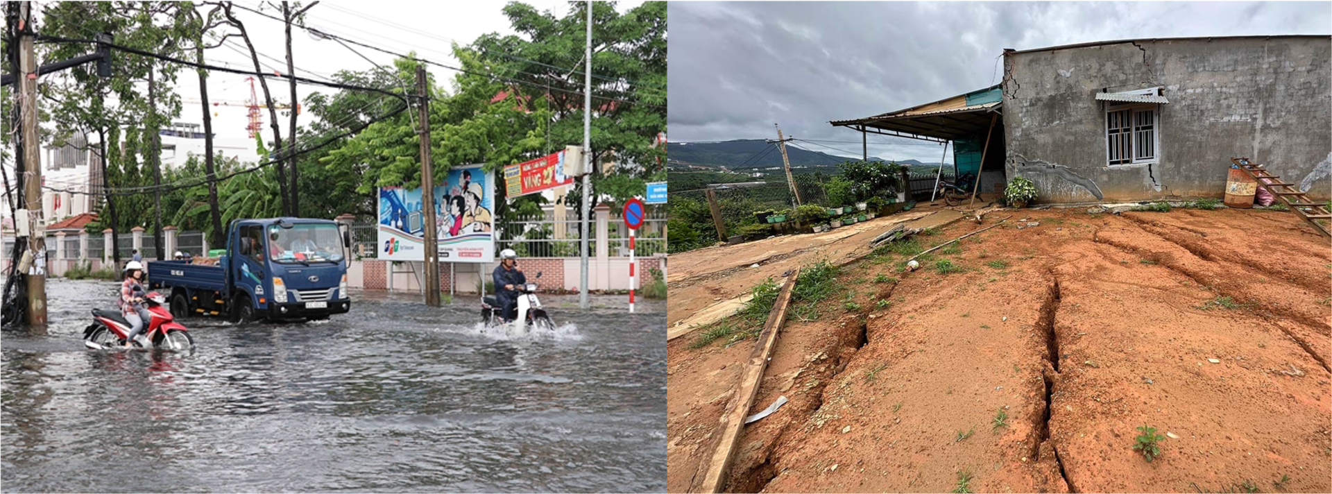
source: right image) https://vietnamnews.vn/environment/548889/hcm-city-mekong-delta-face-serious-land-subsidence.html
left image) https://vnexpress.net/bat-an-voi-sat-lo-sut-lun-dat-o-tay-nguyen-4637340.html
SAR satellite data allows consistent and thorough monitoring, detecting ground deformation that signals impending natural disasters. This detection process enables the timely consideration and implementation of appropriate countermeasures to mitigate their societal impact. Synspective’s LDM will be crucial in assessing these efforts’ usability, efficiency, and effectiveness in addressing societal challenges.
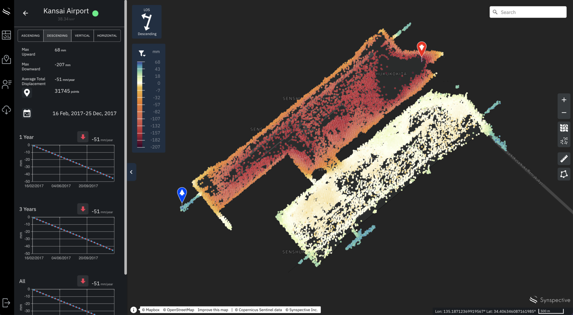
© Mapbox © OpenStreetMap Improve this map | © Copernicus Sentinel data [2014-2023] | © Synspective Inc.
*Synspective LDM image: About LDM service is here
Remarks
National Remote Sensing Department
Ministry of Natural Resources and Environment, Vietnam
General Director
Tran Tuan Ngoc
“We hope that the cooperation between the parties in the field of remote sensing will be a good and sustainable development step and contribute to strengthening the comprehensive strategic partnership between Vietnam and Japan.”
Fujitsu Vietnam Ltd.
Deputy General Director
Jun Hashimoto
“At Fujitsu, we harness the power of technology to address some of the world’s most pressing challenges. Our partnership with Vietnam’s National Remote Sensing Authority and Synspective demonstrates our commitment to using innovative solutions, like satellite remote sensing technology and data analytics, to protect our environment, mitigate natural disasters, and drive socio-economic development. Together, we’re not just envisioning a safer and more prosperous future, we’re helping to build it.”
Synspective Inc.
Executive Officer and General Manager of Business Dept.
Takayuki Odawara
“Through our close, long-term, and comprehensive partnership with the National Remote Sensing Center and Fujitsu Vietnam, Synspective’s SAR intelligence will help address various societal issues across the country.”