

Overview
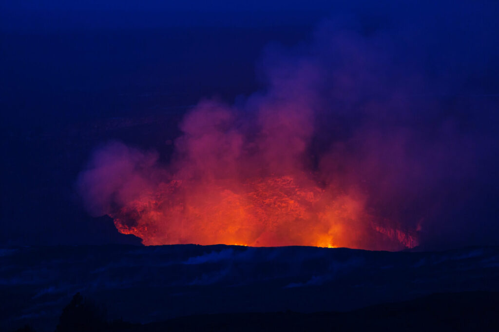
On 14-15 January 2022, a powerful volcanic eruption occurred at the Hunga Tonga-Hungaha’apai volcano in the South Pacific island nation of Tonga. After the massive eruption on 15 January 5 p.m., local time, the volcanic plume rose to a height of about 20 km and spread over a 240 km radius. The shock wave caused tidal changes in Peru, the United States and many other countries around the world. In Japan, a tsunami warning was issued just after midnight on the 16th. The tidal changes have caused widespread floodings in local areas, as well as major power cuts and disruption to communications. We would like to express our deepest sympathy to all those affected and our sincere wishes for your safety and the speedy recovery of the affected areas.
Synspective’s disaster analysis team conducted an analysis of the eruption situation at Hunga Tonga-Fungaha’apai volcano. Four separate Sentinel-1 SAR satellite images were taken between early December 2021 (before the eruption) and 15 January 2022 (after the eruption) and were used to analyse changes in the shape of the island and its surroundings due to eruptive activity.
Analysis Methods
This analysis utilizes data based on the scattering intensity*1 of radio waves from SAR satellites. The polygons in the blue frame indicate changes that may have occurred around the island as a result of eruptive activity.
*1 Scattering Intensity: Microwaves emitted from the SAR sensor are scattered to detect physical properties on the Earth’s surface. Surface roughness has a large impact on scatter intensity.
10 December 2021 – 22 December 2021
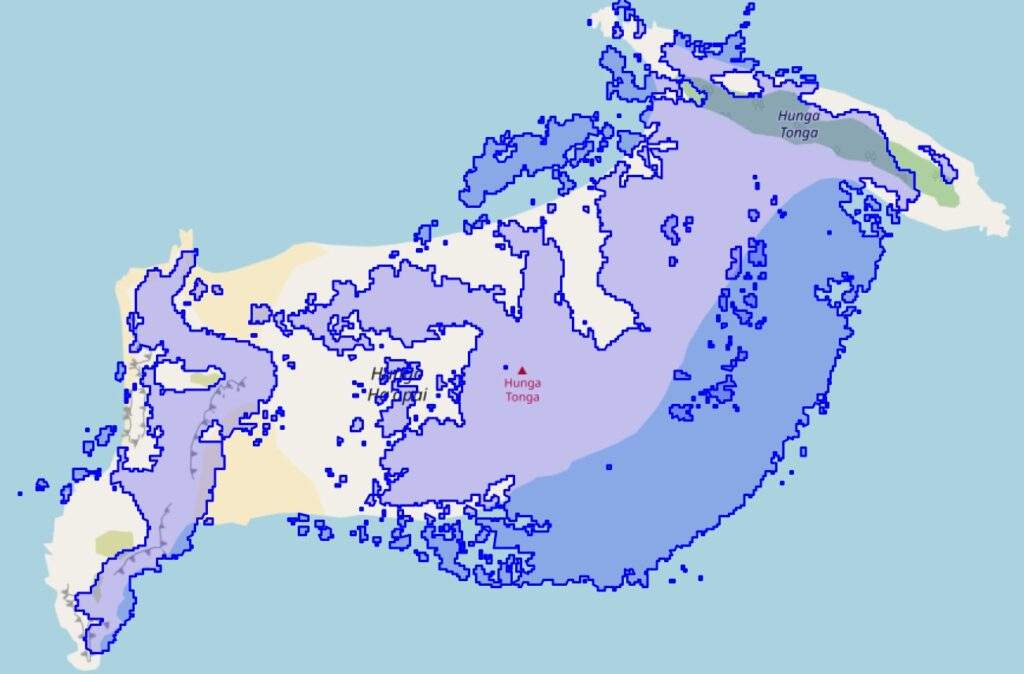
©OpenStreetMap contributors. ©︎Copernicus Sentinel data 2021-2022. ©Synspective Inc.
22 December 2021 – 3 January 2022
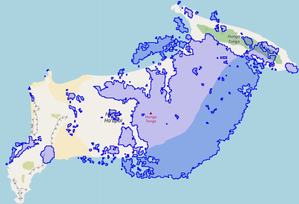
©OpenStreetMap contributors. ©︎Copernicus Sentinel data 2021-2022. ©Synspective Inc.
3 January 2022 – 15 January 2022
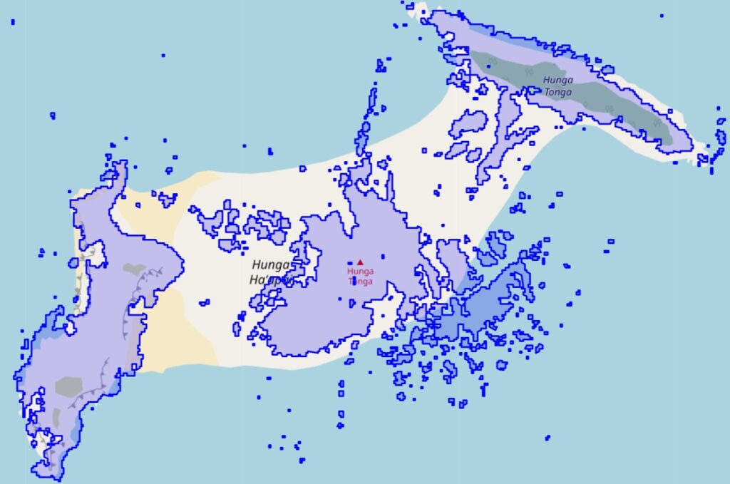
©OpenStreetMap contributors. ©︎Copernicus Sentinel data 2021-2022. ©Synspective Inc.
Analysis Results
The results of analysis using SAR satellite images taken before and after the eruption of the submarine volcano show that the shape of the area around the island has changed over a long period of time due to eruptive activity. The first result suggests that the first eruption occurred on 20 December 2021 and that the island was enlarged at that time. The second result suggests that the eruption activity subsided during the holiday season, and the size of the island decreased. After the massive eruption on 14 and 15 January, changes all over the island were detected. We will continue to examine the results of each analysis in order to develop more accurate algorithms.
Conclusion
When eruptive activities continue and optical images (satellite, aircraft, drone, etc.) cannot be obtained due to cloudy weather, it is useful to monitor eruptive activities using SAR satellite data. Especially in the case of eruptive activity in the distant ocean, satellite data is the best option to monitor these events.
Synspective is developing and operating its own small SAR (Synthetic Aperture Radar) satellites. The company aims to build a constellation of 30 satellites by the late 2020’s, which includes one satellite already in orbit. With a full constellation in low Earth orbit, SAR satellites will be able to observe disasters anywhere in the world within two hours. Unlike traditional observation methods using optical satellites and aircraft / drones, SAR satellites are capable of all-weather ground observations, making it possible to quickly capture ground movements over a wide area.
December 2021 analysis of the damage caused by typhoon Rai in the Philippines
10/2021 Analysis of the volcanic eruption at Mt. Aso in Kumamoto Prefecture
