

Overview
Using satellite data, we analyzed ground movements at locations with road subsidence in Japan and overseas about 150 days prior to their occurences. Synspective’s Land Displacement Monitoring (LDM) can regularly and remotely monitor ground surfaces anywhere on Earth and understand risk over a wide area.
Additionally, with a subsidence area extraction function announced in April 2021 , advanced analysis makes it possible to understand where existing land subsidence problems have occurred and are progressing, as well as map potential future risks. This function uses a unique predictive algorithm that makes detections by multiplying spatio-temporal change features.
Issue
With satellite data, it is possible to understand ground movements from tunnel construction and other activities in units of several millimeters. With time-series analysis of trends in land subsidence, it is possible to detect early warning signs. As such, construction companies can contribute to accident prevention and ensure workplace safety, and the general public can better assess their residential safety. Additionally, it is also possible to generate insurance that incorporates inspection costs for ground change locations, construction cost measures for damage reduction, and additional costs incurred due to interruptions or delays in construction.
Results
Analyzing ground movements where subsidence occurred in vertical and horizontal directions, we identified ground movement changes that seemed to have been affected by areas of subsidence. Synspective’s original algorithm detected these characteristics of change.
Use Case in Japan
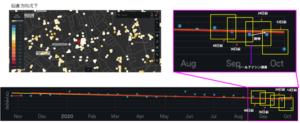
We analyzed ground movements in a tunneling shield located in Japan. From the time-series data above, we identified changes over time as the shield machine proceeded. The slight increase in ground movement coincided with the passing of the shield machine and the effects were visible.
©Mapbox ©OpenStreetMap Improve this map | ©Copernicus Sentinel data [2014-2021] | ©Synspective Inc.
Use Case in Indonesia
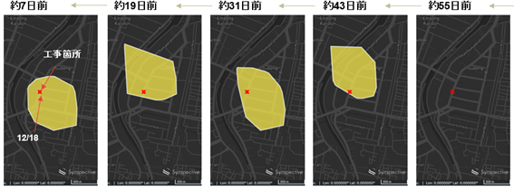
We conducted land subsidence monitoring by InSAR in Surabaya, Indonesia. The marked area on the above map indicates the area of subsidence and the yellow surrounding areas indicate where subsidence risk was determined to be high. About 43 days prior to the sinkhole disaster, the subsidence area was intermittently recognized as a high-risk area.
©Mapbox ©OpenStreetMap Improve this map | ©Copernicus Sentinel data [2014-2021] | ©Synspective Inc.
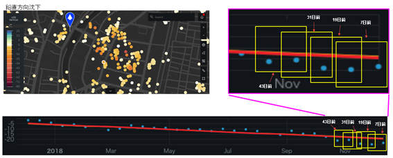
The analysis results on the left side show uplift and subsidence, and the below image with the blue arrow shows a subsidence trend over an approximate year in millimeters. From the enlarged image on the right, it can be seen that there was considerable subsidence 43 days prior to the sinkhole collapse.
©Mapbox ©OpenStreetMap Improve this map | ©Copernicus Sentinel data [2014-2021] | ©Synspective Inc.
Benefits
By analyzing past satellite data where subsidence occurred, we were able to extract time-series ground movements and trends. Given these results, LDM can provide numerous benefits including:
- Monitoring of ground surface impacts from underground tunnel construction
- Efficient and sophisticated road monitoring on a regular basis
- Early detection of subsidence risks over a wide area
- Investigation of past subsidence causes
- Observation of impact at ground facilities
- Alert warnings and near real-time monitoring
Features of the solution
- Able to analyze ground displacement trends in horizontal and vertical directions with millimeter accuracy
- Able to understand historical changes over time with wide-area monitoring capabilities of multiple sites anywhere on Earth simultaneously
- Use of In-SAR analysis technology system
- The first technology in Japan able to detect sinkholes
- Reduced time with automated ground movement analysis
- Easy-to-use user interface
- PDF Report