On October 12th, 2019, the typhoon “Hagibis” struck Japan. While remaining extremely large and strong, generating heavy rain, storms, high waves, and storm surges in a vast area. Its lowest pressure was 915 hPa, the highest wind speed was 162 mph, and the total amount of damage in Japan was said to be 15 billion USD. This typhoon caused more than 300 landslides and collapsed levees at over 70 rivers.
Synspective has analyzed the flood damage of the Abukuma River caused by this typhoon in 2019 using our Flood Damage Assessment solution.

Analysis of the Abukuma River flood by Flood Damage Assessment (FDA)
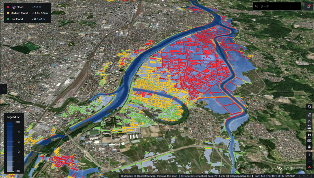
Synspective analysed the flood damage around the Abukuma river, where the damage was severe in the Tohoku region, using Sentinel-1 SAR satellite data, which was observed on Oct.12, 2019, 11:42 PM UTC.
Results
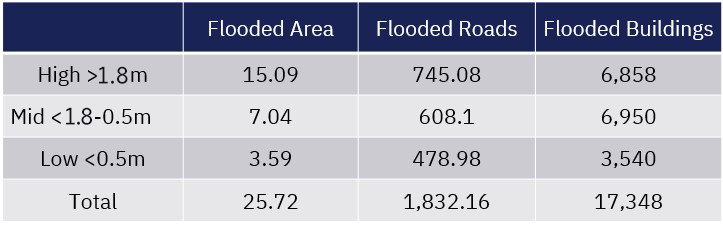
As a result of the analysis, the flooded area at the time of imaging was 25.72㎢, and it is estimated that more than half of the area was flooded with a depth of 1.8m or more. If we assume that more than half of the flooded buildings and roads were 1.8m deep, that means more than 6,800 buildings and 1,800km of roads were damaged. We can see that the buildings and roads around the Abukuma River would have been greatly affected by the flooding.
Data
Features of the solution
- Visualize and quantify which buildings and roads are flooded in targeted areas in 3D
- Intuitive user interface
- Enable to export PDF reports
Differences from other types of the observation data
- Broader observation with information of buildings and roads flooding
- Automatic analysis: No need to be checked or analyzed by a person.
- In addition to ground-based observation data such as water level gauges in rivers, you can obtain information on the extent and depth of floods.
Conclusion
When a disaster occurs, it is necessary to promptly take action to the damage situation based on accurate information.
Synspective is developing and operating its own small SAR (Synthetic Aperture Radar) satellites and aiming to build a constellation of 30 satellites by the latter half of the 2020s. With this low-earth-orbit constellation, satellites will be able to reach and observe disasters in any part of the world within two hours.
Unlike conventional observation methods using optical satellites and aeroplanes/drones, SAR satellites enable all-weather ground observations, quickly determining the presence or absence of inundation damage in broader areas.
Furthermore, utilizing the most advanced analysis methods such as AI and Machine learning, Syspective can identify the range of impact on facilities such as buildings and roads.
In the future, we will be able to grasp the inundation damage more quickly by incorporating data obtained from our small SAR satellite constellation into Flood Damage Assessment. This solution helps the public sectors prioritize the rescue, support and staff allocation to flooded areas, and the insurance companies and companies with their own assets in the struck areas can quickly understand the flood damage and utilise data for decision making.

Other use case.