
With fast revisit times and low costs, SAR satellite systems will unlock new access to valuable data anywhere on Earth. Customer Service Engineer, Ashok Krishnan, spoke about SAR’s special properties in gathering highly valuable information to better understand our changing environment in a recent webinar. Here is, in brief, what we learned and why we think the future of SAR imaging is bright.
What are SAR satellites?
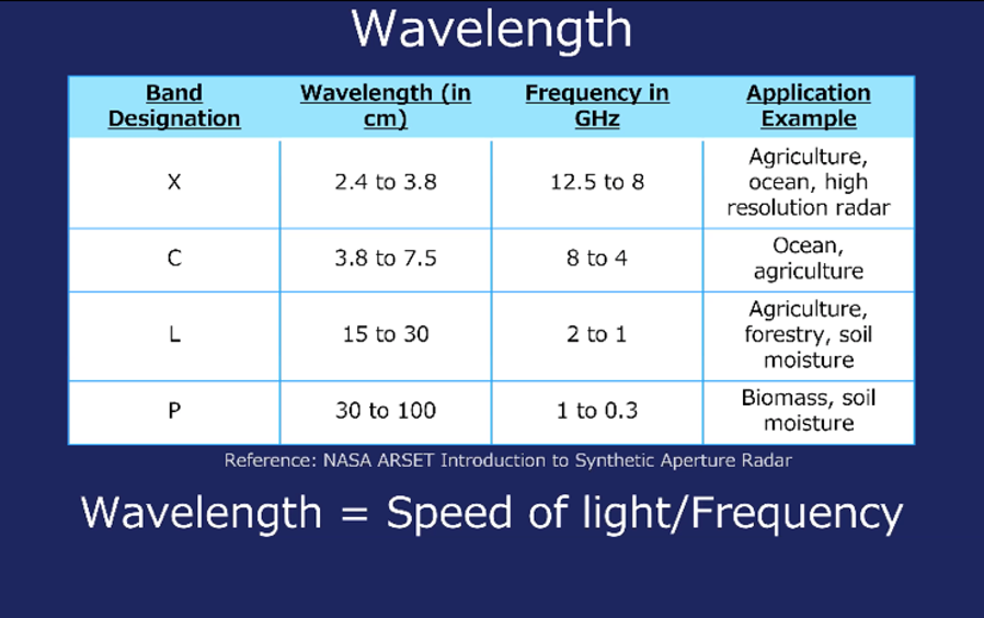
Synthetic Aperture Radar (SAR) satellites have radar sensors that utilize longer wavelengths, giving it the ability to see through any atmospheric or lighting condition. The satellites use two phase datasets for the same locations, showing ground displacements between two datasets along the direction of the beam. SAR satellites operate at frequencies with L-band, X-band, P-band, and C-band wavelengths. Think of it as the satellite’s toolbox kit. Each operates at different lengths and frequency ranges, affecting the type of objects the radar is sensitive to. For example, longer wavelength signals, such as the L-band, are optimal for forest and soil moisture monitoring; C-band sensors find greater applicability in low vegetation areas and imaging ocean and ice features.
In addition to wavelength, radar collects signals in different polarizations, which describe the characteristics of electromagnetic waves to express the orientation of the electric field. SAR satellites can transmit and receive either horizontally or vertically polarized signals to gather information.
Why SAR satellites?
Measuring distances between the sensor and the point of the earth’s surface where the signals are returned after being transmitted, known as a backscattered signal, give SAR satellites some unique distinctions over optical radar systems. Some of these include the following:
1.) SAR can provide its own artificial radiant energy source for illuminations. Passive sensors must rely on radiant energy from natural resources.
2.) SAR can cover expansive areas of the earth’s surface, providing a lot of physical information, but is often affected by speckle noise in its image detection. Optical satellites provide high image clarity to view the world as the human eye does, but are unable to collect a large swath of physical information.
3.) Optic radars are dependent on the day-night cycle. Providing their own source for illumination, SAR can penetrate through clouds, smoke, or rain at any time of night or day.
4.) The longer the length of the antenna, the higher the spatial resolution will be. SAR satellites bypass this by synthesizing a long antenna which grants it the possibility to use longer wavelengths and achieve strong resolution with compact antenna structures. While the weight of optics has been reduced, SAR satellites continue to be very competitive in cost-effectiveness and availability.
How can they address environmental challenges?
Land ecosystems are vulnerable to ongoing climate change. With its impact on land subsidence, SAR technologies will increasingly become a useful tool to observe and manage environmental phenomena such as ground deformation, especially in harsh climatic conditions. In 2020, Synspective decided to launch a land displacement monitoring solution service to enable the detection of timely land displacement over a wide area based on SAR analysis. We can map subsistence at high spatial detail and measurement resolution, revealing real-time insights into controlling and mitigation processes. The data that SAR satellites provide are highly valuable for infrastructure projects, natural disaster monitoring, construction, and mining. The software solution is currently available as a SaaS (software as a service). More information on Synspective’s Land Displacement Monitoring service can be found here.
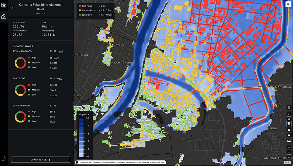
Floods are one of the most devastating and costly natural disasters. SAR satellites can be key to quickly assessing the scale and extent of flooded and affected areas. With models to also predict their occurrences, SAR data can be used to insure risk and protect communities from environmental threats. Synspective offers a solutions service where SAR analysis can offer valuable information to decision makers, including government authorities, civil agencies, city planners, and insurance companies. More information on Synspective’s Flood Damage Assessment service can be found here.
What about the United Nations Sustainable Development Goals?
SAR satellite observation data and analysis can be used in support of the 2030 agenda for sustainable development adopted by United Nations Members States in 2015. That is, the data can serve as a tool to tackle climate change, to make cities and communities more sustainable, protect industrialization and infrastructure, and even help response agencies save lives in risk-prone areas. SAR data provides novel and innovative approaches to contribute to the fulfillment of the UN’s SDGs and other global challenges.
What lies ahead?
Synspective plans to employ a constellation of 30 satellites over the next few years, which will span the entire globe and enable us to identify, track, and map global flooding and land loss in real-time. We are excited about acquiring and delivering data that is easy to interpret and can be used to contribute to the solution to various environmental concerns with space technology. Please follow us on LinkedIn to learn more about our developments and upcoming satellite deployments.