

Ground movements and deformation pose major risks to the safety, stability, and efficiency of mining operations. Synspective’s Global Sales Manager, Bujed Pamungakas, hosted a webinar to introduce how synthetic aperture radar (SAR) satellites can be an effective deformation measurement and monitoring tool for the mining industry.
Conventional monitoring techniques using total station have been around for a long time, but they are known to have high incremental costs and can only be conducted in a limited number of locations. Interferometric Synthetic Aperture Radar (InSAR) techniques have proven to be a cost-effective and accurate solution that makes it possible to monitor ground movements with high precision and frequency. With interferometry, ground displacements over large areas can be extracted from radar images. The intensity of the reflection from the radar wave of the Earth’s surface can accurately capture object detection and classification; the amplitude of the reflected radar wave signal can measure occurring changes and high sensitivity to small displacements on Earth.
Seeking to equip both public and private entities with the data they need to make informed and timely decisions, Synspective launched its first Land Displacement Monitoring (LDM)Land Displacement Monitoring Service in 2020. It enables cost-effective, ground movement monitoring with millimeter detail through SAR image analysis. Customers can track historical change, find patterns, and have advanced understanding of the situation using our cloud-based data platform. With the addition of deep learning algorithms, information is automatically updated to enable customers to derive meaningful insights and make decisions quickly.
We launched our first satellite in December 2020, a first step toward a constellation of 30 satellites scheduled for the late 2020s. A full constellation will provide global imaging coverage of the entire Earth and enhance our spatial and temporal archive of high-resolution imagery and data for analytics and insights. It will also make repeated image captures with higher intervals possible.
The service is offered on a subscription basis through SaaS (solution as a service). More information on cost and analysis can be found here.
A Case Study in Brazil
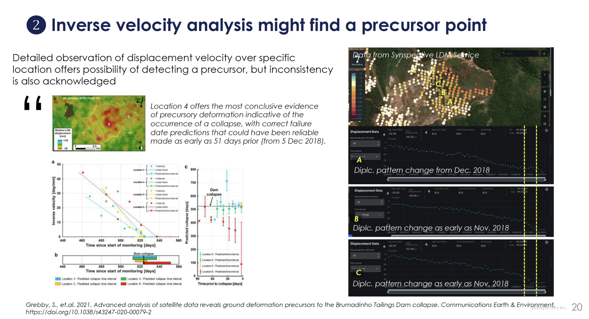
The opportunities for satellite data to drive improvement in mining sectors are wide-ranging. Bujed presented the Brumadinho dam disaster that killed many people and sent millions of tons of toxic waste into several areas of Brazil in 2019. Reviewing professional reports and scientific journals, and acquiring data from our very own service, he could make some observations into the dam burst and how ground deformation through interferometric SAR technique in Synspective’s LDM service can support risk prevention and mitigation activities.

© Mapbox © OpenStreetMap Improve this map|© Copernicus Sentinel data © Synspective Inc.
Pre- and post-disaster research by the mining company, Vale, and various scientists concluded that there was seepage around the wall of tailing dam number 1 and ground deformation in the entire dam area at Còrrego do Feijão. Synspective was able to confirm deformation using the LDM service, which was consistent with other scientific research. While opinions varied over early warnings from the long-term, time-series ground deformation data pattern in the dam area, monitoring ground deformation using InSAR provided possibilities of generating ground information over a wide area with greater data density and frequency at low cost. This will, at least, encourage more precise selection for on-site check once an anomaly is detected.
© Mapbox © OpenStreetMap Improve this map|© Copernicus Sentinel data © Synspective Inc.
Managing Risk
We at Synspective believe that mining companies can leverage SAR satellite data for efficient operations and resource planning and management. Our services can be used to monitor and understand deformation phenomena around mining sites. LDM service is made with a combination of InSAR, AI, and cloud technologies, which enables automated processes, quick decision-making, and quick alert dispatch over anomalous deformation.
Synspective Webinar Report – Why SAR Satellites are making waves